Ajmer district
Appearance
(Redirected from Ajmer District)
Ajmer district
अजमेर जिला | |
|---|---|
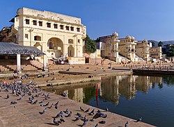
 Ghats along Pushkar Lake | |
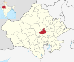
 Location of Ajmer district in Rajasthan | |
| Coordinates (Ajmer): 26°27′N 74°38′E / 26.450°N 74.633°E | |
| Country | |
| State | Rajasthan |
| Division | Ajmer |
| Headquarters | Ajmer |
| Tehsils | 1. Kishangarh, 2. Ajmer, 3. Sarwar, 4. Kekri, 5. Peesangan, 6. Nasirabad, 7. Masuda, 8. Beawar, 9. Bhinay |
| Government | |
| • District collector | Ms. Arti Dogra[1] |
| • Lok Sabha constituencies | 1. Ajmer (shared with Jaipur district), 2. Rajsamand (shared with Nagaur, Pali and Rajsamand districts) |
| • Vidhan Sabha constituencies | 1. Dudu, 2. Ajmer North, 3. Ajmer South, 4. Pushkar, 5. Kisahngarh, 6. Nasirabad, 7. Masuda, 8. Kekri |
| Area | |
| • Total | 8,481 km2 (3,275 sq mi) |
| Population (2011) | |
| • Total | 2,583,052 |
| • Density | 300/km2 (790/sq mi) |
| • Urban | 40.1% |
| Demographics | |
| • Literacy | 69.3% |
| • Sex ratio | 951 |
| Time zone | UTC+05:30 (IST) |
| Vehicle registration | RJ-01 |
| Major highways | NH 48, NH 58, NH 448 |
| Average annual precipitation | 481.3[2] mm |
| Website | ajmer |
Ajmer District is a district in Rajasthan. The city of Ajmer is the district headquarters.
Ajmer District has an area of 8,481 km2, and a population of 2,583,052 (2011 census). Three main religions are; Hindu 1,869,044, Muslim 244,341, Jains 47,812. The district is in the center of Rajasthan, and is bordered to the north by the Nagaur District, to the east by the Jaipur, to the south by the Tonk, Bhilwara District, and to the west by the Pali District.
References
[change | change source]- ↑ "District Administration | Ajmer, Rajasthan Official Website". Retrieved 7 July 2018.
- ↑ "Monsoon Report 2016" (PDF). Retrieved 7 July 2018.
Other websites
[change | change source]Wikimedia Commons has media related to Ajmer district.
