
File:CapeHornDetailMap.png
Size of this preview: 800 × 482 pixels. Other resolutions: 320 × 193 pixels | 640 × 386 pixels | 906 × 546 pixels.
Original file (906 × 546 pixels, file size: 91 KB, MIME type: image/png)
| This is a file from the Wikimedia Commons. Information from its description page there is shown below. Commons is a freely licensed media file repository. You can help. |
Summary
| Description |
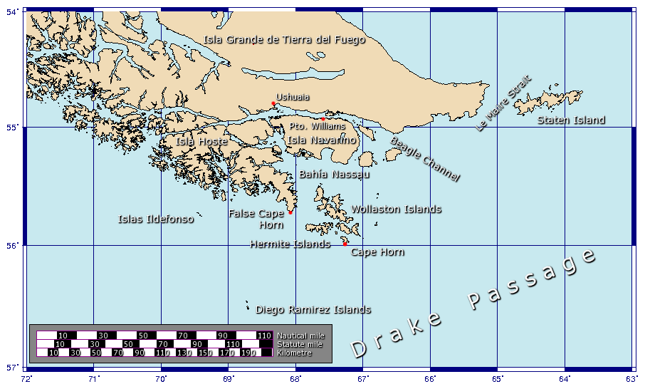
Español: Detalle de las islas cerca del Cabo de Hornos
Generated using GMT. |
| Date | 27 January 2006 (original upload date) |
| Source | Own work |
| Author | Johantheghost |
Licensing
I, the copyright holder of this work, hereby publish it under the following licenses:

|
Permission is granted to copy, distribute and/or modify this document under the terms of the GNU Free Documentation License, Version 1.2 or any later version published by the Free Software Foundation; with no Invariant Sections, no Front-Cover Texts, and no Back-Cover Texts. A copy of the license is included in the section entitled GNU Free Documentation License. |
| This file is licensed under the Creative Commons Attribution-Share Alike 3.0 Unported license. | ||
| ||
| This licensing tag was added to this file as part of the GFDL licensing update. |
This file is licensed under the Creative Commons Attribution-Share Alike 2.5 Generic, 2.0 Generic and 1.0 Generic license.
- You are free:
- to share – to copy, distribute and transmit the work
- to remix – to adapt the work
- Under the following conditions:
- attribution – You must give appropriate credit, provide a link to the license, and indicate if changes were made. You may do so in any reasonable manner, but not in any way that suggests the licensor endorses you or your use.
- share alike – If you remix, transform, or build upon the material, you must distribute your contributions under the same or compatible license as the original.
You may select the license of your choice.
File history
Click on a date/time to view the file as it appeared at that time.
| Date/Time | Thumbnail | Dimensions | User | Comment | |
|---|---|---|---|---|---|
| current | 16:17, 21 November 2009 | | 906 × 546 (91 KB) | Botaurus | functionless line (borderline) removed |
| 12:22, 9 February 2006 |  | 906 × 546 (91 KB) | Johantheghost | Less violent colours. | |
| 00:25, 28 January 2006 |  | 906 × 546 (90 KB) | Johantheghost | Fix scale! | |
| 20:20, 27 January 2006 |  | 906 × 546 (87 KB) | Johantheghost | Scale and false cape | |
| 16:34, 27 January 2006 |  | 906 × 546 (81 KB) | Johantheghost | A map showing the location of Cape Horn, including part of the Drake Passage. Generated using [http://gmt.soest.hawaii.edu/ GMT]. |
File usage
The following page uses this file:
Global file usage
The following other wikis use this file:
- Usage on af.wikipedia.org
- Usage on als.wikipedia.org
- Usage on ar.wikipedia.org
- Usage on ast.wikipedia.org
- Usage on az.wikipedia.org
- Usage on be-tarask.wikipedia.org
- Usage on be.wikipedia.org
- Usage on bg.wikipedia.org
- Usage on br.wikipedia.org
- Usage on bs.wikipedia.org
- Usage on ca.wikipedia.org
- Usage on ceb.wikipedia.org
- Usage on ckb.wikipedia.org
- Usage on cy.wikipedia.org
- Usage on da.wikipedia.org
- Usage on de.wikipedia.org
- Usage on el.wikipedia.org
- Usage on en.wikipedia.org
- Usage on eo.wikipedia.org
- Usage on es.wikipedia.org
- Usage on et.wikipedia.org
- Usage on eu.wikipedia.org
- Usage on fa.wikipedia.org
- Usage on fi.wikipedia.org
- Usage on frr.wikipedia.org
- Usage on fr.wikipedia.org
View more global usage of this file.