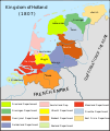
File:Map Kingdom of Holland 1807-en.svg
Appearance

Size of this PNG preview of this SVG file: 505 × 600 pixels. Other resolutions: 202 × 240 pixels | 404 × 480 pixels | 647 × 768 pixels | 862 × 1,024 pixels | 1,725 × 2,048 pixels | 1,902 × 2,258 pixels.
Original file (SVG file, nominally 1,902 × 2,258 pixels, file size: 329 KB)
File history
Click on a date/time to view the file as it appeared at that time.
| Date/Time | Thumbnail | Dimensions | User | Comment | |
|---|---|---|---|---|---|
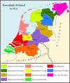
| current | 22:16, 5 February 2022 |  | 1,902 × 2,258 (329 KB) | Magog the Ogre | see Special:Permalink/626968493; note from User:LightPhoenix |
| 12:38, 6 January 2022 |  | 1,902 × 2,258 (329 KB) | Magog the Ogre | copyedit | |
| 03:52, 4 January 2022 |  | 1,902 × 2,258 (329 KB) | Magog the Ogre | == {{int:filedesc}} == {{Information |Description= |Source={{ef|Map_Kingdom_of_Holland_1807-es.svg}} |Date=2021-01-04 03:51 |Author={{u|Joostik}}, {{u|Magog the Ogre}} |Permission= |other_versions={{other versions/Map Kingdom of Holland 1807}} }} == {{int:license-header}} == {{self|cc-by-sa-3.0}} Category:Maps of the Kingdom of Holland Category:English-language maps showing history of Europe Category:English-language SVG maps showing history |
File usage
The following page uses this file:
Global file usage
The following other wikis use this file:
- Usage on en.wikipedia.org
- Usage on fi.wikipedia.org
- Usage on id.wikipedia.org
- Usage on ja.wikipedia.org
- Usage on ko.wikipedia.org
- Usage on mk.wikipedia.org
- Usage on sl.wikipedia.org


