
File:Peedeerivermap.png
No higher resolution available.
Peedeerivermap.png (500 × 415 pixels, file size: 177 KB, MIME type: image/png)
| This is a file from the Wikimedia Commons. Information from its description page there is shown below. Commons is a freely licensed media file repository. You can help. |

|
This map image could be re-created using vector graphics as an SVG file. This has several advantages; see Commons:Media for cleanup for more information. If an SVG form of this image is available, please upload it and afterwards replace this template with
{{vector version available|new image name}}.
It is recommended to name the SVG file “Peedeerivermap.svg”—then the template Vector version available (or Vva) does not need the new image name parameter. |
Summary
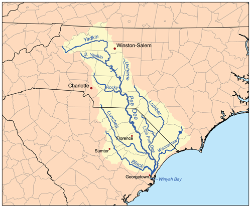
| Description | This is a map of the Pee Dee River watershed. I, Karl Musser, created it based on USGS data. |
| Date | 28 February 2007 (original upload date) |
| Source | No machine-readable source provided. Own work assumed (based on copyright claims). |
| Author | No machine-readable author provided. Kmusser assumed (based on copyright claims). |
| Other versions | File:Peedee-highrocklake.png |
Licensing
I, the copyright holder of this work, hereby publish it under the following license:
This file is licensed under the Creative Commons Attribution-Share Alike 2.5 Generic license.
- You are free:
- to share – to copy, distribute and transmit the work
- to remix – to adapt the work
- Under the following conditions:
- attribution – You must give appropriate credit, provide a link to the license, and indicate if changes were made. You may do so in any reasonable manner, but not in any way that suggests the licensor endorses you or your use.
- share alike – If you remix, transform, or build upon the material, you must distribute your contributions under the same or compatible license as the original.
File history
Click on a date/time to view the file as it appeared at that time.
| Date/Time | Thumbnail | Dimensions | User | Comment | |
|---|---|---|---|---|---|
| current | 17:27, 28 February 2007 | | 500 × 415 (177 KB) | Kmusser | spelling fix |
| 17:02, 28 February 2007 |  | 500 × 415 (177 KB) | Kmusser | This is a map of the Pee Dee River watershed. I, Karl Musser, created it based on USGS data. {{self|cc-by-sa-2.5}} Category:Maps of rivers of the United States |
File usage
The following page uses this file:
Global file usage
The following other wikis use this file:
- Usage on ar.wikipedia.org
- Usage on arz.wikipedia.org
- Usage on bg.wikipedia.org
- Usage on ca.wikipedia.org
- Usage on da.wikipedia.org
- Usage on de.wikipedia.org
- Usage on en.wikipedia.org
- Pee Dee River
- Lynches River
- List of rivers of North Carolina
- Yadkin River
- List of rivers of South Carolina
- Waccamaw River
- Little Pee Dee River
- Black River (South Carolina)
- Johnsonville crater
- User:Kmusser/Images
- Lumber River
- Cheraw
- Rocky River (North Carolina)
- Yadkin–Pee Dee River Basin
- South Yadkin River
- User:Tisquesusa/sandbox9
- User:CarolineJS1963/sandbox/csc126/final
- Usage on es.wikipedia.org
- Usage on fr.wikipedia.org
- Usage on hu.wikipedia.org
- Usage on ja.wikipedia.org
- Usage on no.wikipedia.org
- Usage on pl.wikipedia.org
- Usage on ru.wikipedia.org
- Usage on uk.wikipedia.org
- Usage on www.wikidata.org