Joondalup
Appearance
(Redirected from Joondalup, Western Australia)
| Joondalup Perth, Western Australia | |||||||||||||||
|---|---|---|---|---|---|---|---|---|---|---|---|---|---|---|---|
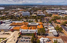
 Aerial view of Joondalup | |||||||||||||||
 | |||||||||||||||
| Coordinates | 31°44′42″S 115°45′58″E / 31.745°S 115.766°E | ||||||||||||||
| Established | 1980s | ||||||||||||||
| Postcode(s) | 6027 | ||||||||||||||
| Area | 11.8 km2 (4.6 sq mi) | ||||||||||||||
| Location | 26 km (16 mi) from Perth | ||||||||||||||
| LGA(s) | City of Joondalup | ||||||||||||||
| State electorate(s) | Joondalup | ||||||||||||||
| Federal division(s) | Moore | ||||||||||||||
| |||||||||||||||
Joondalup is a suburb and regional city in Perth, Western Australia. It was established in the 1980s. In 2001, the suburb had a population of 6,927. The suburb was named after Lake Joondalup which is located on the eastern side of the suburb. In relation to the other establishments in Perth, Joondalup is a relatively new settlement, as it was undeveloped until the 1960s.
