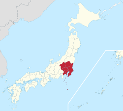
Kantō region
Kanto region
関東地方 | |
|---|---|
 The Kanto region in comparison to the rest of Japan | |
 Closeup map of the areas within the Kanto region | |
| Area | |
| • Total | 32,423.90 km2 (12,518.94 sq mi) |
| Population (October 1, 2010) | |
| • Total | 42,607,376 |
| • Density | 1,300/km2 (3,400/sq mi) |
| GDP | |
| • Total | $2.1 trillion |
| • Per capita | $50,000 |
| Time zone | UTC+9 (JST) |
The Kantō region (関東地方, Kantō-chihō) is one of Japan's regions.[3] The Japanese conventions of geography and history divide the nation into eight regions, including the Kantō region.[4] These have been used since 1905 as basic units for description and comparison[5] and as cultural markers.
The regions of Japan are a fusion of historical divisions and modern administrative needs".[6] The significance of the region in Japan is geographical, cultural and administrative.[7]
History
[change | change source]In the late 7th century, the Tōkaidō region were identified as one of the eight largest administrative areas of the Imperial system (ritsuryo seido).
Gokishichidō is an ancient system of names for parts of the country, including Tōkaidō.[8] Kantō covers an east-central area of the island of Honshū[9] in roughly the same area as the traditional Tōkaidō.
The region of Kantō covers the east-central part of the island of Honshū.
In the Meiji period, the modern regional system was made by Imperial decree. Japan was divided into regions (chihō Archived 2017-03-24 at the Wayback Machine), including the Kantō region. A regional council (chihō gyōsei kyōgisai) was headed by the governor of the most powerful prefecture in the regional grouping. The council also included regional chiefs of central government ministries.[10]
Table: Kanto Region
[change | change source]Over time, Kantō developed its own regional dialects, customs and unique traditional culture.[11]
Timeline
[change | change source]- 1923 (Taishō 12): Great Kantō earthquake[12] has its epicenter near Tokyo and Yokohama.[13]
Geography
[change | change source]The region includes the Greater Tokyo Area. The Kantō covers seven prefectures: Gunma, Tochigi, Ibaraki, Saitama, Tokyo, Chiba, and Kanagawa.
Subdivisions
[change | change source]North and South subdivisions are sometimes used:
- "North Kantō" (北関東, Kita Kantō) covering Ibaraki, Tochigi, and Gunma.
- "South Kantō" (南関東, Minami-Kantō) covering Saitama, Chiba, Tokyo and Kanagawa. South Kantō is often used as synonymous with the Greater Tokyo Area.
East and West subdivisions are sometimes used:
- East Kantō (東関東, Higashi-Kantō): Ibaraki, Tochigi and Chiba.
- West Kantō (西関東, Nishi-Kantō): Gunma, Saitama, Tokyo, Kanagawa (and Yamanashi Prefecture may be included).
Inland and Coastal subdivisions are sometimes used:
- Inland Kantō (関東内陸部, Kantō nairiku-bu): Tochigi, Gunma, Saitama (and Yamanashi may be included).
- Coastal Kantō (関東沿岸部, Kantō engan-bu): Ibaraki, Chiba, Tokyo and Kanagawa.
Greater Kantō
[change | change source]The Japanese national government defines the National Capital Region (首都圏, Shuto-ken) as the Kantō region plus Yamanashi Prefecture.
Japan's national public broadcaster NHK defines the "Kantō broadcast area" (関東甲信越, Kantō-kō-shin-etsu) which includes Yamanashi, Nagano and Niigata Prefectures for regional programming.
Related pages
[change | change source]
| Kinai | Tōkaidō | Tōsandō | Hokurikudō |
| San'indō | San'yōdō | Nankaidō | Saikaidō |
References
[change | change source]- ↑ "International comparison of GDP of Japan's Prefectures: Tokyo's GDP is bigger than Indonesia's?!". realestate.co.jp. August 13, 2015. Archived from the original on May 1, 2018. Retrieved February 3, 2017.
- ↑ "Yearly Average Rates". UKForex. Archived from the original on March 16, 2015. Retrieved February 3, 2017.
- ↑ Nussbaum, Louis-Frédéric. (2005). "Kanto" in Japan Encyclopedia, pp. 478-479, p. 478, at Google Books
- ↑ Library of Congress Country Studies, Japan (LOC), "Geographic Regions"; "The islands of Hokkaido, Shikoku, and Kyushu each form a region, and the main island of Honshu is divided into five regions". Retrieved 2012-4-3.
- ↑ Tames, Richard. (2008). A traveller's history of Japan, p. 264.
- ↑ Japan Ministry of Foreign Affairs (MOFA), "Regions of Japan". Retrieved 2012-4-11.
- ↑ Brandt, Kim. Kingdom of Beauty: Mingei and the Politics of Folk Art in Imperial Japan, pp. 218-219;Shapira, Philip et al. (1994). Planning For Cities And Regions In Japan, p. 193, citing Research Institute of Construction and Economy. (1991). "Fig. 2-7. "Regional Vitalization and Construction Administration," White Paper on Construction. Retrieved 2012-8-28.
- ↑ Nussbaum, "Goki-shichidō" at p. 255.
- ↑ LOC, "Kanto". Retrieved 2012-2-14.
- ↑ Steiner, Kurt. (1965). Local Government in Japan, p. 62.
- ↑ Web-Japan.org, "Regions of Japan". Retrieved 2012-4-15.
- ↑ Nussbaum, "Taishō Tennō" at p. 929.
- ↑ "Yokohama is Practically Destroyed," The New York Times. September 3, 1923. Retrieved 2012-2-15.
Other websites
[change | change source]


