Sánchez, Dominican Republic
Sánchez | |
|---|---|
Municipality | |
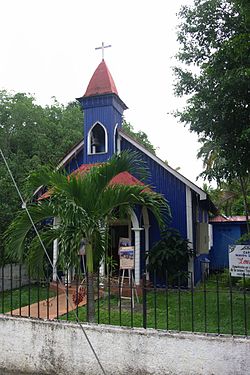
 Our Lady of Lourdes chapel, Sánchez | |
| Coordinates: 19°13′N 69°36′W / 19.217°N 69.600°W | |
| Country | |
| Province | Samaná |
| Municipality since | 1866 |
| Area | |
| • Total | 340.1 km2 (131.3 sq mi) |
| Elevation | 7 m (23 ft) |
| Population (2014)[1] | |
| • Total | 24,509 |
| • Density | 72/km2 (190/sq mi) |
| • Urban | 11,211 |
| Time zone | UTC-4 (AST) |
| • Summer (DST) | UTC-4 (AST) |
| Distance: | 34 km (21 mi) to Samaná |
Sánchez is a Dominican municipality in the Samaná province, on the south coast of the peninsula of Samaná.
Name
[change | change source]Sánchez is named after Francisco del Rosario Sánchez, one of the three Founding Fathers of the Dominican Republic.
History
[change | change source]The old town of Las Cañitas was elevated to the category of municipality in 1866.
It was a very small town but it grew in importance and population when the railway from the town to La Vega began to run across the rich region of the Cibao. Sánchez became the most important port of the country during the rest of the 19th century and beginning of the 20th century. The railway worked until 1966.[3]
The port lost its importance when other ports in the country grew in importance. And the Yuna River has been filling the Samaná Bay with solid materials and only small boats can get to the port.
Population
[change | change source]The municipality had, in 2014, a total population of 24,509: 12,583 men and 11,926 women. The urban population was 45.7% of the total population.[1]
Geography
[change | change source]Sánchez has a total area of 340.1 km2 (131 sq mi), about 39.4% of the total area of the province of Samaná.[1] The city is an elevation of 7 m (23 ft) above sea level,[2] and at 34 km (21 mi) to the west of Samaná.
The city is surrounded by mountains of the Sierra de Samaná, a small mountain range that covers most of the Samaná peninsula.
Sánchez does not have any municipal district.[4]
The municipality of Sánchez has the Atlantic Ocean to the northwest, the municipality of Las Terrenas to the north, the municipality of Samaná to the east, the Duarte and María Trinidad Sánchez provinces to the west and the Samaná Bay to the south. It also borders, in its southeastern part, to the Hato Mayor province.
Climate
[change | change source]Sánchez has a tropical wet climate (Köppen-Geiger classification: Af) with no dry or cold season as it is constantly moist (rainfalls during the whole year).[5]
The average amount of rainfall for the year in the city is 2,064.5 mm (81.3 in). The month with the most precipitation on average is May with 236.3 mm (9.3 in) of rainfall, followed by November with 225.2 mm (8.9 in).
The driest season is winter. The month with the least rainfall on average is February with an average of 96.6 mm (3.8 in) and the second is March with 112 mm (4.4 in).
Samaná is in a warm region; the average temperature for the year is 26.7 °C (80.1 °F). The warmest month, on average, is July with an average temperature of 28.05 °C (82.5 °F). The coolest month on average is January, with an average temperature of 25 °C (77.0 °F).
| Climate data for Sánchez (1961–1990) | |||||||||||||
|---|---|---|---|---|---|---|---|---|---|---|---|---|---|
| Month | Jan | Feb | Mar | Apr | May | Jun | Jul | Aug | Sep | Oct | Nov | Dec | Year |
| Average high °C (°F) | 29.8 (85.6) |
30.1 (86.2) |
30.5 (86.9) |
30.9 (87.6) |
31.7 (89.1) |
32.3 (90.1) |
32.4 (90.3) |
32.1 (89.8) |
32.3 (90.1) |
32.2 (90.0) |
30.4 (86.7) |
29.5 (85.1) |
31.2 (88.1) |
| Daily mean °C (°F) | 25 (77) |
25.3 (77.5) |
25.7 (78.3) |
26.1 (79.0) |
27.3 (81.1) |
28 (82) |
28.1 (82.6) |
27.8 (82.0) |
27.8 (82.0) |
27.7 (81.9) |
26.2 (79.2) |
25.2 (77.4) |
26.7 (80.0) |
| Average low °C (°F) | 20.2 (68.4) |
20.4 (68.7) |
20.8 (69.4) |
21.3 (70.3) |
22.8 (73.0) |
23.7 (74.7) |
23.7 (74.7) |
23.5 (74.3) |
23.3 (73.9) |
23.1 (73.6) |
22 (72) |
20.8 (69.4) |
22.1 (71.9) |
| Average rainfall mm (inches) | 123.5 (4.86) |
96.6 (3.80) |
112 (4.4) |
147.1 (5.79) |
236.3 (9.30) |
154.1 (6.07) |
195 (7.7) |
219.4 (8.64) |
183.4 (7.22) |
190.9 (7.52) |
225.2 (8.87) |
181 (7.1) |
2,064.5 (81.27) |
| Source 1: NOAA[6] | |||||||||||||
| Source 2: Climatemps.com[5] | |||||||||||||
Economy
[change | change source]The main economic activity of the municipality is farming. Fishing was the main activity but now is not so important.
References
[change | change source]- ↑ 1.0 1.1 1.2 1.3 Consejo Nacional de Población y Familia. "Estamaciones y Proyecciones de la Población Dominicana por Regiones, Provincias, Municipios y Distritos Municipales, 2014" (PDF) (in Spanish). Retrieved 2014-02-02.
- ↑ 2.0 2.1 De la Fuente, Santiago (1976). Geografía Dominicana (in Spanish). Santo Domingo, Dominican Republic: Editora Colegial Quisqueyana.
- ↑ Vega, Bernardo (2004). Breve historia de Samaná (in Spanish). Santo Domingo: Fundación Cultural Dominicana. ISBN 9993427063.
- ↑ "División Territorial 2015" (in Spanish). Oficina Nacional de Estadística (ONE). October 2015. Archived from the original (PDF) on 14 November 2015. Retrieved 22 November 2016.
- ↑ 5.0 5.1 "Sanchez Climate & Temperature". Climatemps.com. Retrieved 22 November 2016.
- ↑ "Sanchez Climate Normals 1961-1990". National Oceanic and Atmospheric Administration. Retrieved 22 November 2016.

