1707 Hōei earthquake
 | |
| Local date | 28 October 1707 |
|---|---|
| Local time | 14:00 [1] |
| Magnitude | 8.6 ML, Mw 8.7[2] |
| Epicenter | 33°00′N 136°00′E / 33.0°N 136.0°E |
| Fault | Nankai megathrust |
| Areas affected | Japan: Chūbu region, Kansai region, Shikoku, Kyūshū |
| Tsunami | yes |
| Casualties | >5,000[1] |
The 1707 Hōei earthquake happened at 14:00 local time on 28 October 1707. It was one of the largest earthquakes in Japanese history.[1]
Background
[change | change source]The southern coast of Honshu runs in the same direction as the Nankai Trough. This marks the place where the Philippine Sea Plate moves under the Eurasian Plate. Movement on this boundary causes many earthquakes; some of them are megathrust earthquakes. The Nankai megathrust has five parts (A-E) that can break one by one.[3][4] The different parts have broken either one at a time or all together many times over the last 1,300 years.[5] This kind of quake often happens in pairs with a relatively short time between them. In addition to the two earthquakes in 1854, there were similar earthquakes in 1944 and 1946. Each time, the north-eastern part broke before the southwestern part.[6] In 1707, the earthquakes were either at the same time, or close enough together so that writing from that time do not describe them separately.
Damage
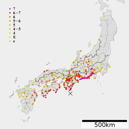
[change | change source]29,000 houses were destroyed and more than 5,000 people were killed. The earthquake caused at least one major landslide in Shizuoka.[7] This landslide was one of the three largest in Japan and is called the Ohya Landslide. It covered an area of 1.8 km2 with an estimated volume of 120 million m3.[8] In the Nara Basin, the earthquake made the soil behave like a liquid.[9]
Characteristics
[change | change source]Earthquake
[change | change source]There were two other very large earthquakes: the 1854 Ansei-Tōkai and Ansei-Nankai earthquakes. The 1707 was stronger than both. Several observations show that the Hōei earthquake was bigger. At Cape Muroto, Kōchi, a cliff was raised up about 2.3 m in 1707, but just 1.5 m in 1854. In the Kawachi Plain area, the earthquake was around 6 - 7 on the JMA scale. Also, the amount of damage and height of the water from tsunami showed the strength of the earthquake. There are also records of tsunami at distant locations, such as Nagasaki and Jeju-do, South Korea.[10]
Tsunami
[change | change source]The tsunami that followed the earthquake raised water along the coast. Along the southwestern coast of Kōchi, the average increase in sea level was 7.7 m. In some places it rose up to 10.2 m[11]
Connection to Mount Fuji eruption
[change | change source]Changes in stress caused by large earthquakes may be enough to cause volcanic eruptions, when the magma system of the volcano is close to a critical state.[12] The great earthquake in 1707 may have changed pressure in the magma under Mount Fuji and might have caused the last eruption of Mount Fuji 49 days later.[12]
Related pages
[change | change source]References
[change | change source]- ↑ 1.0 1.1 1.2 IISEE. "Catalog of Damaging Earthquakes in the World (Through 2007)". Retrieved 2009-12-23.
- ↑ Chesley, Christine; Lafemina, Peter C.; Puskas, Christine; Kobayashi, Daisuke (2012). "The 1707 Mw8.7 Hoei earthquake triggered the largest historical eruption of Mt. Fuji". Geophysical Research Letters. 39 (24): n/a. Bibcode:2012GeoRL..3924309C. doi:10.1029/2012GL053868. S2CID 128457540.
- ↑ Ando, M. (1975). "Source mechanisms and tectonic significance of historical earthquakes along the nankai trough, Japan". Tectonophysics. 27 (2): 119–140. Bibcode:1975Tectp..27..119A. doi:10.1016/0040-1951(75)90102-X. Archived from the original on 2019-01-11. Retrieved 2009-11-13.
- ↑ Ishibashi, K. (2004). "Status of historical seismology in Japan" (PDF). Annals of Geophysics. 47 (2/3): 339–368. Retrieved 2009-11-22.
- ↑ Sieh, K.E. (1981). A Review of Geological Evidence for Recurrence Times of Large Earthquakes (PDF). Archived from the original (PDF) on 2010-06-04. Retrieved 2009-11-13.
- ↑ Kaneda, Y. (2007). "Precise real-time observatory and simulating phenomena of earthquakes and tsunamis around the Nankai Trough - Towards the understanding of mega thrust earthquakes -". 2007 Symposium on Underwater Technology and Workshop on Scientific Use of Submarine Cables and Related Technologies. Kawaguchi, K.; Araki, E.; Matsumoto, H.; Nakamura, T.; Kamiya, S.; Hori, T. & Baba, T. pp. 299–300. doi:10.1109/UT.2007.370806. ISBN 978-1-4244-1207-5. S2CID 45347574. Retrieved 2009-11-13.
- ↑ Sidle, R.C.; Imaizumi F. (2008). "Triggering Mechanisms of Landslides and Debris Flows and Their Linkages: Hydrogeomorphic and Hydropedologic Influences" (PDF). 1st International Conference on Hydropedology Highlights of Presentations. Archived from the original (PDF) on 27 July 2011. Retrieved 30 January 2010.
- ↑ "Case 2: Oya Hillside work" (PDF). Retrieved 30 January 2010.
- ↑ Nakanashi, I. (1999). "Liquefaction Caused by the 1707 Hoei Earthquake as Observed in the Nara Basin, Central Japan". Disaster Prevention Research Institute Annuals, Kyoto University. 42 (B1): 125–127. Archived from the original on 2012-02-25. Retrieved 2010-01-30.
- ↑ Tsuji, Y.; Namegaya Y. (2007). "The 1707 Hoei Earthquake, as an Example of a combined Gigantic Tokai-Nankai Earthquake" (PDF). Archived from the original (PDF) on 11 June 2011. Retrieved 23 December 2009.
- ↑ Hatori, T. (1981). "Field investigations of the Nankaido Tsunamis in 1707 and 1854 along the South-west coast of Shikoku" (PDF) (in Japanese and English). 56. Bulletin Earthquake Research Institute: 547–570. Archived from the original (PDF) on 2011-10-06. Retrieved 2009-12-23.
{{cite journal}}: Cite journal requires|journal=(help) - ↑ 12.0 12.1 Hill, D.P.; Pollitz F. & Newhall C. (2002). "Earthquake-Volcano Interactions" (PDF). Physica Today. 55 (November): 41–47. Bibcode:2002PhT....55k..41H. doi:10.1063/1.1535006. Archived from the original (PDF) on 2011-08-15. Retrieved 2010-01-30.


