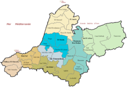
Aïn Témouchent Province
Appearance
Aïn Témouchent Province
ولاية عين تموشنت | |
|---|---|
 Administrative map of Aïn Témouchent province | |
 Map of Algeria highlighting Aïn Témouchent | |
| Coordinates: 35°18′N 01°08′W / 35.300°N 1.133°W | |
| Country | Algeria |
| Capital | Aïn Témouchent |
| Government | |
| • PPA president | Mr. Tikhmarine Lakhdar (FLN) |
| • Wāli | Mr. Bouderbali Mohamed |
| Area | |
| • Total | 2,376.89 km2 (917.72 sq mi) |
| Population (2010)[1] | |
| • Total | 384,565 |
| • Density | 160/km2 (420/sq mi) |
| Time zone | UTC+01 (CET) |
| Area Code | +213 (0) 27 |
| ISO 3166 code | DZ-46 |
| Districts | 8 |
| Municipalities | 28 |
Aïn Témouchent is a province in northwestern Algeria. The capital is Aïn Témouchent.
Districts
[change | change source]The province has 8 districts and 28 municipalities.
The districts are:
References
[change | change source]- ↑ Wilaya d'Aïn Témouchent Présentation/Population/Répartition de la population
