Amberley, New Zealand
Appearance
Amberley
Kōwai (Māori) | |
|---|---|
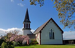
 Holy Innocent's Anglican Church, Amberley | |
 | |
| Coordinates: 43°9′20″S 172°43′50″E / 43.15556°S 172.73056°E | |
| Country | New Zealand |
| Region | Canterbury |
| Territorial authority | Hurunui District |
| Ward | South Ward |
| Electorates | |
| Government | |
| • Territorial Authority | Hurunui District Council |
| • Regional council | Environment Canterbury |
| • Mayor of Hurunui | Marie Black |
| • Kaikoura MP | Stuart Smith |
| • Te Tai Tonga MP | Tākuta Ferris |
| Area | |
| • Total | 3.63 km2 (1.40 sq mi) |
| Population (June 2023)[2] | |
| • Total | 2,380 |
| • Density | 660/km2 (1,700/sq mi) |
| Postcode | 7410 |
| Local iwi | Ngāi Tahu |
Amberley is a town in the Hurunui District of the South Island. It is located on State Highway 1 approximately 50 kilometers north of Christchurch and is 11 kilometers south of Waipara. It has a primary school and an Anglican church situated in the town.
References
[change | change source]- ↑ "ArcGIS Web Application". statsnz.maps.arcgis.com. Retrieved 29 April 2024.
- ↑ "Subnational population estimates (RC, SA2), by age and sex, at 30 June 1996-2023 (2023 boundaries)". Statistics New Zealand. Retrieved 25 October 2023. (regional councils); "Subnational population estimates (TA, SA2), by age and sex, at 30 June 1996-2023 (2023 boundaries)". Statistics New Zealand. Retrieved 25 October 2023. (territorial authorities); "Subnational population estimates (urban rural), by age and sex, at 30 June 1996-2023 (2023 boundaries)". Statistics New Zealand. Retrieved 25 October 2023. (urban areas)
