Arrondissement of Brioude
Brioude | |
|---|---|
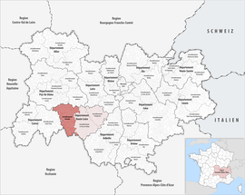
 Location within the region Auvergne-Rhône-Alpes | |
| Country | France |
| Region | Auvergne-Rhône-Alpes |
| Department | Haute-Loire |
| No. of communes | 111 |
| Subprefecture | Brioude |
| Area | 1,886.8 km2 (728.5 sq mi) |
| Population (Jan. 2019)[1] | 45,057 |
| INSEE code | 431 |
The arrondissement of Brioude is an arrondissement of France. It is part of the Haute-Loire département. Its capital is the city of Brioude, a subprefecture of the department.
History
[change | change source]When the Haute-Loire department was created on 4 March 1790, the arrondissement of Brioude was part of that original department.[2]
Geography
[change | change source]The arrondissement of Brioude is bordered to the north by the Puy-de-Dôme department, to the east by the arrondissement of Le Puy-en-Velay, to the south and southwest by the Lozère department and to the west by the Cantal department.
It is the most western of the arrondissements of the department, with an area of 1,886.8 km2 (728.5 sq mi),[3] the second largest of the department but it is the one with fewest people living in it with 45,848 inhabitants and a density of 24.3 inhabitants/km².[4]
The Allier river flows through this arrondissement.
Composition
[change | change source]Cantons
[change | change source]After the reorganisation of the cantons in France,[5] cantons are not subdivisions of the arrondissements so they could have communes that belong to different arrondissements.
In the arrondissement of Brioude, there are 5 cantons:
- Brioude (4304)
- Gorges de l'Allier-Gévaudan (4307)
- Pays de Lafayette (4310)
- Plateau du Haut-Velay granitique (4311) (partly)
- Sainte-Florine (4317)
Communes
[change | change source]The arrondissement of Brioude has 111 communes; they are (with their INSEE codes):[6]
- Agnat (43001)
- Ally (43006)
- Arlet (43009)
- Aubazat (43011)
- Vissac-Auteyrac (43013)
- Autrac (43014)
- Auvers (43015)
- Auzon (43016)
- Azérat (43017)
- Beaumont (43022)
- Berbezit (43027)
- La Besseyre-Saint-Mary (43029)
- Blassac (43031)
- Blesle (43033)
- Bonneval (43035)
- Bournoncle-Saint-Pierre (43038)
- Brioude (43040)
- Cerzat (43044)
- La Chaise-Dieu (43048)
- Chambezon (43050)
- Champagnac-le-Vieux (43052)
- Chanaleilles (43054)
- Chaniat (43055)
- Chanteuges (43056)
- La Chapelle-Geneste (43059)
- Charraix (43060)
- Chassagnes (43063)
- Chassignolles (43064)
- Chastel (43065)
- Chavaniac-Lafayette (43067)
- Chazelles (43068)
- Chilhac (43070)
- La Chomette (43072)
- Cistrières (43073)
- Cohade (43074)
- Collat (43075)
- Connangles (43076)
- Couteuges (43079)
- Cronce (43082)
- Cubelles (43083)
- Desges (43085)
- Domeyrat (43086)
- Espalem (43088)
- Esplantas-Vazeilles (43090)
- Félines (43093)
- Ferrussac (43094)
- Fontannes (43096)
- Frugerès-les-Mines (43099)
- Frugières-le-Pin (43100)
- Grenier-Montgon (43103)
- Grèzes (43104)
- Javaugues (43105)
- Jax (43106)
- Josat (43107)
- Lamothe (43110)
- Langeac (43112)
- Laval-sur-Doulon (43116)
- Lavaudieu (43117)
- Lavoûte-Chilhac (43118)
- Lempdes-sur-Allagnon (43120)
- Léotoing (43121)
- Lorlanges (43123)
- Lubilhac (43125)
- Malvières (43128)
- Mazerat-Aurouze (43131)
- Mazeyrat-d'Allier (43132)
- Mercœur (43133)
- Monistrol-d'Allier (43136)
- Montclard (43139)
- Paulhac (43147)
- Paulhaguet (43148)
- Pébrac (43149)
- Pinols (43151)
- Prades (43155)
- Saint-Arcons-d'Allier (43167)
- Saint-Austremoine (43169)
- Saint-Beauzire (43170)
- Saint-Bérain (43171)
- Saint-Christophe-d'Allier (43173)
- Saint-Cirgues (43175)
- Saint-Didier-sur-Doulon (43178)
- Saint-Étienne-sur-Blesle (43182)
- Sainte-Eugénie-de-Villeneuve (43183)
- Sainte-Florine (43185)
- Saint-Georges-d'Aurac (43188)
- Saint-Géron (43191)
- Saint-Hilaire (43193)
- Saint-Ilpize (43195)
- Saint-Julien-des-Chazes (43202)
- Saint-Just-près-Brioude (43206)
- Saint-Laurent-Chabreuges (43207)
- Sainte-Marguerite (43208)
- Saint-Pal-de-Senouire (43214)
- Saint-Préjet-Armandon (43219)
- Saint-Préjet-d'Allier (43220)
- Saint-Privat-du-Dragon (43222)
- Saint-Vénérand (43225)
- Saint-Vert (43226)
- Salzuit (43232)
- Saugues (43234)
- Sembadel (43237)
- Siaugues-Sainte-Marie (43239)
- Tailhac (43242)
- Thoras (43245)
- Torsiac (43247)
- Vals-le-Chastel (43250)
- Venteuges (43256)
- Vergongheon (43258)
- Vézézoux (43261)
- Vieille-Brioude (43262)
- Villeneuve-d'Allier (43264)
The communes with more inhabitants in the arrondissement are:
| INSEE code |
Commune | Population[4] (2014) |
Canton | Intercommunality |
|---|---|---|---|---|
| 43040 | Brioude | 6,700 | Brioude | Le Brivadois |
| 43112 | Langeac | 3,758 | Gorges de l'Allier-Gévaudan | Les Rives du Haut-Allier |
| 43185 | Sainte-Florine | 3,079 | Sainte-Florine | Auzon Communauté |
| 43258 | Vergongheon | 1,834 | Sainte-Florine | Auzon Communauté |
| 43234 | Saugues | 1,814 | Gorges de l'Allier-Gévaudan | Les Rives du Haut-Allier |
| 43132 | Mazeyrat-d'Allier | 1,520 | Pays de Lafayette | Les Rives du Haut-Allier |
| 43120 | Lempdes-sur-Allagnon | 1,327 | Sainte-Florine | Auzon Communauté |
| 43262 | Vieille-Brioude | 1,225 | Brioude | Le Brivadois |
| 43038 | Bournoncle-Saint-Pierre | 1,005 | Brioude | Le Brivadois |
Related pages
[change | change source]References
[change | change source]- ↑ "Téléchargement du fichier d'ensemble des populations légales en 2019". The National Institute of Statistics and Economic Studies. 28 December 2020.
- ↑ "Historique de la Haute-Loire". Le SPLAF (in French). Retrieved 28 September 2017.
- ↑ "Arrondissement de Brioude (431)". Comparateur de territoire (in French). Institut national de la statistique et des études économiques - INSEE. Retrieved 28 September 2017.
- ↑ 4.0 4.1 "Régions, départements, arrondissements, cantons et communes" (PDF). Populations légales 2014 (in French). Institut national de la statistique et des études économiques - INSEE. Retrieved 28 September 2017.
- ↑ "Décret n° 2014-162 du 17 février 2014 portant délimitation des cantons dans le département de la Haute-Loire" (in French). Légifrance.gouv.fr. Retrieved 27 September 2017.
- ↑ "Arrondissement de Brioude (431)" (in French). Institut national de la statistique et des études économiques - INSEE. Retrieved 28 September 2017.
