Banská Bystrica
Appearance
Banská Bystrica | |
|---|---|
City | |
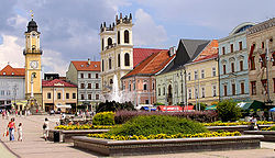
 Banská Bystrica's main square | |
| Etymology: "mining creek" | |
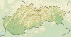
Location of Banská Bystrica in the Banská Bystrica Region | |
| Coordinates: 48°44′07″N 19°08′43″E / 48.73528°N 19.14528°E | |
| Country | |
| Region | Banská Bystrica |
| District | Banská Bystrica |
| First mentioned | 1255 |
| Government | |
| • Mayor | Ján Nosko |
| Area | |
| • Total | 103.38 km2 (39.92 sq mi) |
| (2022) | |
| Elevation | 362 m (1,188 ft) |
| Population | |
| • Total | 74,590 |
| • Density | 720/km2 (1,900/sq mi) |
| Time zone | UTC+1 (CET) |
| • Summer (DST) | UTC+2 (CEST) |
| Postal code | 97401 |
| Area code | +421-48 |
| Car plate | BB |
| Website | eng.banskabystrica.sk |
Banská Bystrica (German: Neusohl, Hungarian: Besztercebánya, Latin: Villa Nova), is a large town in central Slovakia, on the Hron river.
History
[change | change source]It was first mentioned in 1255 as a royal free mining town. The town had rich ore deposits, mainly copper, and to a lesser extent silver, gold and iron. As the deposits were depleted, the town has reoriented to the industry. During the World War II, the Slovak National Uprising broke out in the town.
Sister cities
[change | change source] - Durham, England
 - Hradec Králové, Czech Republic
 - Salgótarján, Hungary
 - Tula, Russia
 - Herzliya, Israel
 - Larissa, Greece
 - Montana, Bulgaria
 - Tarnobrzeg, Poland
 - Zadar, Croatia
 - Ascoli Piceno, Italy
 - Halberstadt, Germany
 - Dabas, Hungary
 - Budva, Montenegro
 - Radom, Poland
 - Kovačica, Serbia
 - Vršac, Serbia
References
[change | change source]- ↑ Statistical Office of the Slovak Republic (www.statistics.sk). "Hustota obyvateľstva - obce". www.statistics.sk. Retrieved 2024-02-08.
- ↑ Statistical Office of the Slovak Republic (www.statistics.sk). "Počet obyvateľov podľa pohlavia - obce (ročne)". www.statistics.sk. Retrieved 2024-02-08.
Other websites
[change | change source]Wikimedia Commons has media related to Banská Bystrica.


