
Bieujac
Bieujac | |
|---|---|
 Town hall | |
Location of Bieujac  | |
 Bieujac  Bieujac | |
| Coordinates: 44°32′25″N 0°09′14″W / 44.5403°N 0.1539°W | |
| Country | France |
| Region | Nouvelle-Aquitaine |
| Department | Gironde |
| Arrondissement | Langon |
| Canton | Le Sud-Gironde |
| Intercommunality | Sud Gironde |
| Government | |
| • Mayor (2020–2026) | Frédéric Birac[1] |
| Area 1 | 6.97 km2 (2.69 sq mi) |
| Population (Jan. 2019)[2] | 639 |
| • Density | 92/km2 (240/sq mi) |
| Time zone | UTC+01:00 (CET) |
| • Summer (DST) | UTC+02:00 (CEST) |
| INSEE/Postal code | 33050 /33210 |
| Elevation | 13–58 m (43–190 ft) (avg. 26 m or 85 ft) |
| 1 French Land Register data, which excludes lakes, ponds, glaciers > 1 km2 (0.386 sq mi or 247 acres) and river estuaries. | |
Bieujac is a commune. It is found in the Nouvelle-Aquitaine region in the Gironde department in the southwest of France. In 2020, 655 people lived there.
Geography
[change | change source]Bieujac has a total area of 7 square kilometres (2.7 sq mi).It is about 47 kilometres (29 mi) southeast of Bordeaux and about 8 kilometres (5.0 mi) east of Langon.
Sights
[change | change source]The church of the village, Notre-Dame, was originally built in the 11th century. Between 1830 and 1884 it was rebuilt in Romanesque Revival style. There also is a lavoir, and a monument to soldiers fallen in war.
-
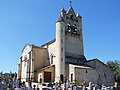 Church Notre-Dame
 -
 Former lavoir
 -
 Monument to the fallen soldiers


References
[change | change source]- ↑ "Répertoire national des élus: les maires" (in French). data.gouv.fr, Plateforme ouverte des données publiques françaises. 13 September 2022.
- ↑ "Populations légales 2019". The National Institute of Statistics and Economic Studies. 29 December 2021.