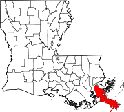
Buras-Triumph, Louisiana
Appearance
Buras-Triumph | |
|---|---|
Former Census-designated place | |
 Fallen water tower following Hurricane Katrina | |
| Coordinates: 29°21′06″N 89°30′50″W / 29.35167°N 89.51389°W | |
| Country | United States |
| State | Louisiana |
| Parish | Plaquemines |
| Area | |
| • Total | 7.2 sq mi (19 km2) |
| • Land | 5.0 sq mi (13 km2) |
| • Water | 2.2 sq mi (6 km2) |
| Elevation | 3 ft (0.9 m) |
| Population (2000) | |
| • Total | 3,358 |
| • Density | 470/sq mi (180/km2) |
| Time zone | UTC-6 (CST) |
| • Summer (DST) | UTC-5 (CDT) |
| Area code | 504 |
Buras-Triumph is an unincorporated community in Plaquemines Parish, Louisiana, United States.[1][2] The population was 3,358 at the 2000 census. On the peninsula, Buras is higher, with Triumph southeast of Buras.
Buras-Triumph has become famous as the location where, on August 29, 2005, at 6:10 AM CDT, the eye of Hurricane Katrina made its strongest landfall. However, the storm surge and high winds began on the previous day, August 28, 2005. During those 2 days, the area was destroyed as a result.
References
[change | change source]- ↑ "Buras-Triumph, Louisiana (LA) Detailed Profile" (notes), City Data, 2007, webpage: C-BT.
- ↑ "Census 2000 Data for the State of Louisiana" (town list), US Census Bureau, May 2003, webpage: C2000-LA.
Other websites
[change | change source]![]() Media related to Buras, Louisiana at Wikimedia Commons
Media related to Buras, Louisiana at Wikimedia Commons


