Canal de Saint-Quentin
Appearance
| Canal de Saint-Quentin | |
|---|---|
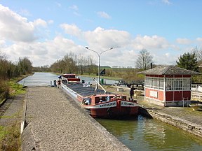
 Lock Noyelles-sur-Escaut on Canal Saint-Quentin | |
| Specifications | |
| Length | 92.5 km (57.5 mi) |
| Maximum boat length | 38.50 m (126.3 ft) |
| Maximum boat beam | 5.05 m (16.6 ft) |
| Minimum boat draft | 2.20 m (7.2 ft) |
| Minimum boat air draft | 3.50 m (11.5 ft) |
| Locks | 35 |
| Total rise | 43 m |
| Status | Open |
| History | |
| Former names | Canal Crozat or Canal de Picardie between Chauny and Saint-Simon, in 1738 |
| Current owner | Voies Navigables de France |
| Principal engineer | Original engineer named Devicq in 1727. Died in 1742. |
| Other engineer(s) | Revised plan by Laurent de Lyonne. Work began in 1768. |
| Date completed | 1810 |
| Geography | |
| Start point | Canalised Escaut River (Scheldt) in Cambrai |
| End point | Chauny |
| Beginning coordinates | 50°10′35″N 3°13′18″E / 50.17646°N 3.22173°E |
| Ending coordinates | 49°36′29″N 3°13′31″E / 49.60814°N 3.22526°E |
| Connects to | |
The Canal de Saint-Quentin is a canal in northern France. It connects the canalised river Escaut in Cambrai to the Canal latéral à l'Oise and Canal de l'Oise à l'Aisne in Chauny.
The first part was built between Chauny and Saint-Simon in 1738. Napoleon opened the second part in April 1810. [1]
References
[change | change source]- ↑ McKnight, Hugh (2005). Cruising French Waterways, 4th Edition. Sheridan House. pp. 16, 37–42. ISBN 978-1-57409-087-1.
