Coal Run Village, Kentucky
Appearance
Coal Run Village, Kentucky | |
|---|---|
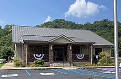
 Coal Run City hall | |
 Location of Coal Run Village in Pike County, Kentucky. | |
| Coordinates: 37°32′14″N 82°33′28″W / 37.53722°N 82.55778°W | |
| Country | United States |
| State | Kentucky |
| County | Pike |
| Incorporated | July 4, 1963 |
| Government | |
| • Type | City Commission |
| Area | |
| • Total | 8.79 sq mi (22.78 km2) |
| • Land | 8.79 sq mi (22.78 km2) |
| • Water | 0.00 sq mi (0.00 km2) |
| Elevation | 991 ft (302 m) |
| Population | |
| • Total | 1,669 |
| • Density | 189.77/sq mi (73.27/km2) |
| Time zone | UTC-5 (Eastern (EST)) |
| • Summer (DST) | UTC-4 (EDT) |
| ZIP codes | 41501 |
| Area code | 606 |
| FIPS code | 21-16084 |
| Website | www |
Coal Run Village is a city of Kentucky in the United States.
References
[change | change source]- ↑ "2020 U.S. Gazetteer Files". United States Census Bureau. Retrieved March 18, 2022.
- ↑ 2.0 2.1 U.S. Geological Survey Geographic Names Information System: Coal Run Village, Kentucky
- ↑ "Coal Run Village city, Kentucky". United States Census Bureau. Retrieved November 10, 2023.
