Curaçao
Curaçao Kòrsou | |
|---|---|
| Country of Curaçao Land Curaçao (Dutch) Pais Kòrsou (Papiamento) | |
| Anthem: "Himno di Kòrsou" (English: "Anthem of Curaçao") | |
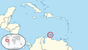
 Location of Curaçao (circled in red) | |
| State | Kingdom of the Netherlands |
| Before separation | Netherlands Antilles |
| Country status | 10 October 2010 |
| Capital and largest city | Willemstad 12°7′N 68°56′W / 12.117°N 68.933°W |
| Official languages | |
| Common languages |
|
| Ethnic groups (2018) | 75.4% Curaçao 9% Dutch 3.6% Dominican 3% Colombian 1.2% Haitian 1.2% Surinamese 1.1% Venezuelan 1.1% Aruban 0.9% unspecified 6% other[1] |
| Demonym(s) | Dutch |
| Government | Parliamentary representative democracy within a constitutional monarchy |
• Monarch | Willem-Alexander |
• Governor | Lucille George-Wout |
| Eugene Rhuggenaath | |
| Legislature | Estates of Curaçao |
| Area | |
• Total | 444[2] km2 (171 sq mi) |
| Highest elevation | 375 m (1,230 ft) |
| Population | |
• 1 January 2019 estimate | 163,424[2] (190th) |
• Density | 358/km2 (927.2/sq mi) |
| GDP (PPP) | 2012[3] estimate |
• Total | US$4.2 billion (184th) |
• Per capita | $25,771 (46th) |
| GDP (nominal) | 2019[4] estimate |
• Total | US$3.2 billion (149th) |
• Per capita | $19,414 (27th) |
| HDI (2012) | 0.811[5] very high |
| Currency | Netherlands Antillean guilder (ANG) |
| Time zone | UTC-4:00 (AST) |
| Mains electricity | 127 V–50 Hz |
| Driving side | right |
| Calling code | +5999 |
| ISO 3166 code | |
| Internet TLD | .cw |
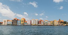
Curaçao is an island country in the Caribbean Sea. It is one of the ABC islands and is just a short distance north of the Venezuelan Paraguaná Peninsula, and it forms a part of the Kingdom of the Netherlands. Willemstad is the capital of Curaçao.
People
[change | change source]
The largest ethnic group belongs to the Afro-Caribbean group with about 85% of the entire population (also includes mulattos). The remaining 15% are people of mainly European (mainly Dutch) descent, but there are also Indonesians, Colombians, Venezuelans, and others.
Languages
[change | change source]Papiamentu, Dutch, and English are the three official languages of Curaçao. Papiamentu is by far the most spoken language while sizable minorities speak the other two official languages.
Climate
[change | change source]Curaçao has a tropical climate. The temperatures are usually constant. The trade winds bring cool breeze during the day and the same trade winds bring warmth during the night. The coolest month is January with an average of 26°C in temperature and the warmest month is September with an average temperature of 28.9 °C (84 °F). The year's average maximum temperature is 31°C. The year's average minimum temperature is about 25°C.
The island broke off from the Netherlands Antilles in 2010. It has a very long history set all the way back to the 1800s.
References
[change | change source]- ↑ "The World Factbook – Central Intelligence Agency". cia.gov. Archived from the original on 23 April 2020. Retrieved 29 December 2019.
- ↑ 2.0 2.1 "Waaruit bestaat het Koninkrijk der Nederlanden? - Rijksoverheid.nl". 19 May 2015.
- ↑ "Country Report Curaçao". Rabobank. Archived from the original on 23 August 2017. Retrieved 23 August 2017.
- ↑ COUNTRY COMPARISON GDP PURCHASING POWER PARITY Archived 2019-01-07 at the Wayback Machine, Central Intelligence Agency.
- ↑ "Human Development Index (HDI): Korte Notitie inzake de berekening van de voorlopige Human Development Index (HDI) voor Curaçao" (PDF). Centraal Bureau voor de Statistiek. Archived from the original (PDF) on 13 July 2015. Retrieved 13 July 2015.


