Dering Harbor, New York
Appearance
Dering Harbor, New York | |
|---|---|
| Incorporated Village of Dering Harbor | |
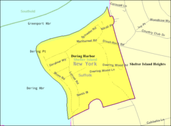
 U.S. Census map of Dering Harbor. | |
 Location within Suffolk County and the state of New York. | |
| Coordinates: 41°5′35″N 72°20′43″W / 41.09306°N 72.34528°W | |
| Country | |
| State | |
| County | Suffolk |
| Town | Shelter Island |
| Incorporated | 1916 |
| Area | |
| • Total | 0.26 sq mi (0.67 km2) |
| • Land | 0.25 sq mi (0.64 km2) |
| • Water | 0.01 sq mi (0.03 km2) |
| Elevation | 7 ft (2 m) |
| Population (2020) | |
| • Total | 50 |
| • Density | 203.25/sq mi (78.59/km2) |
| Time zone | UTC-5 (Eastern (EST)) |
| • Summer (DST) | UTC-4 (EDT) |
| ZIP Code | 11965 |
| Area codes | 631, 934 |
| FIPS code | 36-20379 |
| GNIS feature ID | 0948345 |
| Website | deringharborvillage |
Dering Harbor is a village in the Town of Shelter Island, in Suffolk County, New York, United States. As of the 2020 census, the village population was 50. It is the least populous village in the State of New York.
References
[change | change source]- ↑ "ArcGIS REST Services Directory". United States Census Bureau. Retrieved September 20, 2022.


