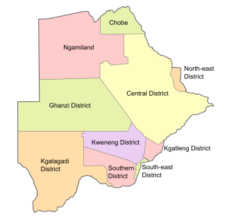
Districts of Botswana
Appearance
| Districts of Botswana | |
|---|---|
 Districts of Botswana. The seven urban districts are not shown. Districts of Botswana. The seven urban districts are not shown. | |
| Category | Unitary State |
| Location | Republic of Botswana |
| Number | 17 Districts |
| Populations | 3,598 (Sowa) – 576,064 (Central District) |
| Areas | 17 km2 (6.6 sq mi) (Orapa) – 142,076 km2 (54,856 sq mi) (Central District) |
| Government | District government |
| Subdivisions | Sub-district |
Botswana is divided into 17 administrative districts: 10 rural districts and 7 urban districts. These are administered by 16 local authorities (district councils, city councils or town councils).[1][2]
| District | Population |
|---|---|
| Gaborone City | 231592 |
| Francistown City | 98961 |
| Lobatse Town | 29007 |
| Selebi-Phikwe Town | 49411 |
| Jwaneng Town | 18008 |
| Orapa Town | 9531 |
| Sowa Township | 3598 |
| Southern District | 197767 |
| South-East District | 85014 |
| Kweneng District | 304549 |
| Kgatleng District | 91660 |
| Central District | 576064 |
| North-East District | 60264 |
| Ngamiland District | 152284 |
| Chobe District | 23347 |
| Ghanzi District | 43095 |
| Kgalagadi District | 50752 |
| Total |
References
[change | change source]- ↑ "2011 Population & Housing Census Analytical Report" (PDF). Archived from the original (PDF) on 2017-10-30. Retrieved 2017-07-17.
- ↑ Botswana Government Ministries & Authorities Archived 2017-06-06 at the Wayback Machine
