Electoral district of Colton
Appearance
| Colton South Australia—House of Assembly | |||||||||||||||
|---|---|---|---|---|---|---|---|---|---|---|---|---|---|---|---|
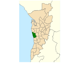
 Electoral district of Colton (green) in the Greater Adelaide area | |||||||||||||||
| State | South Australia | ||||||||||||||
| Created | 1993 | ||||||||||||||
| MP | Matt Cowdrey | ||||||||||||||
| Party | Liberal | ||||||||||||||
| Namesake | Mary Colton | ||||||||||||||
| Electors | 27,600 (2018) | ||||||||||||||
| Area | 26.22 km2 (10.1 sq mi) | ||||||||||||||
| Demographic | Metropolitan | ||||||||||||||
| Coordinates | 34°54′48″S 138°30′40″E / 34.91333°S 138.51111°E | ||||||||||||||
| |||||||||||||||
| Footnotes | |||||||||||||||
| Electoral District map[1] | |||||||||||||||
Colton is an electoral district of South Australia. It was created in 1993.
Colton is in Adelaide.
Election results
[change | change source]| 2022 South Australian state election: Colton | |||||
|---|---|---|---|---|---|
| Party | Candidate | Votes | % | ±% | |
| Liberal | Matt Cowdrey | 13,171 | 52.3 | +6.1 | |
| Labor | Paul Alexandrides | 9,277 | 36.8 | +3.7 | |
| Greens | Deb Cashel | 2,759 | 10.9 | +5.6 | |
| Total formal votes | 25,207 | 97.5 | |||
| Informal votes | 657 | 2.5 | |||
| Turnout | 25,864 | 91.1 | |||
| Two-party-preferred result | |||||
| Liberal | Matt Cowdrey | 13,816 | 54.8 | −1.4 | |
| Labor | Paul Alexandrides | 11,391 | 45.2 | +1.4 | |
| Liberal hold | Swing | −1.4 | |||
References
[change | change source]- ↑ Electoral District of Colton (Map). Electoral Commission of South Australia. 2018. Retrieved 1 April 2018.[permanent dead link]
