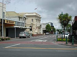
Eltham, New Zealand
Appearance
Eltham | |
|---|---|
 The town centre of Eltham | |
 | |
| Coordinates: 39°25′47″S 174°17′57″E / 39.42972°S 174.29917°E | |
| Country | New Zealand |
| Region | Taranaki |
| Territorial authority | South Taranaki District |
| Ward |
|
| Community | Eltham-Kaponga Community |
| Electorates | |
| Government | |
| • Territorial Authority | South Taranaki District Council |
| • Regional council | Taranaki Regional Council |
| Area | |
| • Total | 3.41 km2 (1.32 sq mi) |
| Population (June 2023)[2] | |
| • Total | 2,080 |
| • Density | 610/km2 (1,600/sq mi) |
| Postcode | 4322 |
Eltham is a town in the South Taranaki District, New Zealand. It is located 50 kilometers south of New Plymouth, 11 kilometers south of Stratford, 13 kilometers east of Kaponga and 19 kilometers north of Hāwera. It is situated on State Highway 3 and is the largest of the Taranaki dairy industry. It has a primary school located in the town. From 1901 to 1989 it was a borough until it was adsorbed into South Taranaki District in 1989. It is the home of All Black and Taranaki rugby player Brian Muller.
References
[change | change source]- ↑ "ArcGIS Web Application". statsnz.maps.arcgis.com. Retrieved 23 March 2023.
- ↑ "Subnational population estimates (RC, SA2), by age and sex, at 30 June 1996-2023 (2023 boundaries)". Statistics New Zealand. Retrieved 25 October 2023. (regional councils); "Subnational population estimates (TA, SA2), by age and sex, at 30 June 1996-2023 (2023 boundaries)". Statistics New Zealand. Retrieved 25 October 2023. (territorial authorities); "Subnational population estimates (urban rural), by age and sex, at 30 June 1996-2023 (2023 boundaries)". Statistics New Zealand. Retrieved 25 October 2023. (urban areas)
