Foggia
Appearance
Foggia
Fògge (Neapolitan) | |
|---|---|
| Comune di Foggia | |
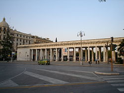
 The Villa Comunale in Foggia | |
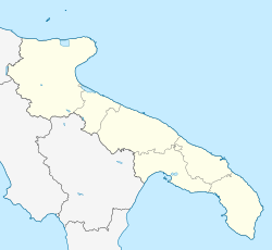
 Foggia within the Province of Foggia | |
| Coordinates: 41°27′51″N 15°32′46″E / 41.46417°N 15.54611°E | |
| Country | Italy |
| Region | |
| Province | Foggia (FG) |
| Frazioni | Arpinova, Incoronata, Cervaro, Tavernola, Segezia, Duanera La Rocca |
| Government | |
| • Mayor | Franco Landella (from 09/06/2014) |
| Area | |
| • Total | 507 km2 (196 sq mi) |
| Elevation | 76 m (249 ft) |
| Population (31/12/2013)[2] | |
| • Total | 153,143 |
| • Density | 300/km2 (780/sq mi) |
| Demonym | Foggians |
| Time zone | UTC+1 (CET) |
| • Summer (DST) | UTC+2 (CEST) |
| Postal code | 71121 - 71122 |
| Dialing code | 0881 |
| Patron saint | Madonna dei Sette Veli |
| Saint day | March 22 |
| Website | www |
Foggia is a city in the region of Apulia, Italy. It is the capital of the Province of Foggia.
References
[change | change source]- ↑ "Superficie di Comuni Province e Regioni italiane al 9 ottobre 2011". Italian National Institute of Statistics. Retrieved 16 March 2019.
- ↑ All demographics and other statistics from the Italian statistical institute (Istat).


