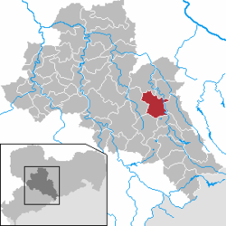
Freiberg, Saxony
Appearance
Freiberg | |
|---|---|
 Freiberg | |
| Coordinates: 50°54′43″N 13°20′34″E / 50.91194°N 13.34278°E | |
| Country | Germany |
| State | Saxony |
| District | Mittelsachsen |
| Subdivisions | 12 |
| Government | |
| • Mayor | Sven Krüger (SPD) |
| Area | |
| • Total | 48.05 km2 (18.55 sq mi) |
| Elevation | 400 m (1,300 ft) |
| Population (2022-12-31)[1] | |
| • Total | 40,485 |
| • Density | 840/km2 (2,200/sq mi) |
| Time zone | UTC+01:00 (CET) |
| • Summer (DST) | UTC+02:00 (CEST) |
| Postal codes | 09599 |
| Dialling codes | 03731 |
| Vehicle registration | FG |
| Website | www |
Freiberg (i.e. free mountain) is a town in the Free State of Saxony, Germany, capital of the Freiberg Rural District.
The town was founded in 1186 and has been a centre of the mining industry in the Ore Mountains for centuries.
In 1944, the Flossenburg concentration camp built a subcamp outside the town of Freiberg. It housed over 500 female survivors of other camps, including Auschwitz Birkenau. Altogether 50 or so SS women worked in this camp until its evacuation in April 1945. The female survivors later reached the Mauthausen concentration camp in Austria.
References
[change | change source]- ↑ "Einwohnerzahlen nach Gemeinden als Excel-Arbeitsmappe" (XLS) (in German). Statistisches Landesamt des Freistaates Sachsen. 2024.
Other websites
[change | change source]![]() Media related to Freiberg at Wikimedia Commons
Media related to Freiberg at Wikimedia Commons


