Günzburg (district)
Appearance
Günzburg | |
|---|---|
 | |
| Country | Germany |
| State | Bavaria |
| Adm. region | Swabia |
| Capital | Günzburg |
| Area | |
| • Total | 763 km2 (295 sq mi) |
| Population (31 December 2022)[1] | |
| • Total | 130,112 |
| • Density | 170/km2 (440/sq mi) |
| Time zone | UTC+01:00 (CET) |
| • Summer (DST) | UTC+02:00 (CEST) |
| Vehicle registration | GZ, KRU |
| Website | landkreis-guenzburg.de |
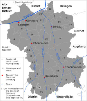
Günzburg is a rural district in Swabia in southwestern Bavaria, Germany. It is next to Dillingen (district), Augsburg (district), Unterallgäu, Neu-Ulm (district), and in Baden-Württemberg: Alb-Donau and Heidenheim (district);
Coat of arms and History
[change | change source]
|
On the right there are the old arms of the margraviate of Burgau, a part of Austria which ruled large parts of the district from 1305 until 1806. On the left: The eagle is from the arms of the Schwabegg-Ursberg family. This family founded two monasteries in the district. |
Geography / Nature
[change | change source]The place is formed by rivers that flow from the south to the Danube, which runs in the north of the district: Biber (Danube), Günz, Kammel, Mindel and Zusam. The Nau flows from the north to the Danube. The hills between the rivers are covered with wood in parts. The eastern third of the district is part of the Augsburg Western Forests Nature Park.
Towns and municipalities
[change | change source]
| Towns | Municipalities | |
|---|---|---|
References
[change | change source]- ↑ Genesis Online-Datenbank des Bayerischen Landesamtes für Statistik Tabelle 12411-003r Fortschreibung des Bevölkerungsstandes: Gemeinden, Stichtag (Einwohnerzahlen auf Grundlage des Zensus 2011) .


