Golden Valley County, Montana
Appearance
Golden Valley County | |
|---|---|
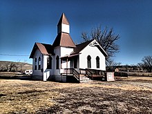
 Grace Lutheran Church of Barber in Ryegate, Montana | |
 Location within the U.S. state of Montana | |
 Montana's location within the U.S. | |
| Coordinates: 46°23′N 109°10′W / 46.38°N 109.17°W | |
| Country | |
| State | |
| Founded | March 8, 1920[1] |
| Seat | Ryegate |
| Largest town | Ryegate |
| Area | |
| • Total | 1,176 sq mi (3,050 km2) |
| • Land | 1,175 sq mi (3,040 km2) |
| • Water | 1.0 sq mi (3 km2) 0.08% |
| Population (2020) | |
| • Total | 823 |
| • Density | 0.70/sq mi (0.27/km2) |
| Time zone | UTC−7 (Mountain) |
| • Summer (DST) | UTC−6 (MDT) |
| Congressional district | 2nd |
| Website | www |
| |
Golden Valley County is a county found in the U.S. state of Montana. As of the 2020 United States Census, there were 823 people.[2] Its county seat is Ryegate.[3]
References
[change | change source]- ↑ "About Golden Valley County". Archived from the original on 2019-01-14. Retrieved 2019-02-15.
- ↑ "QuickFacts: Golden Valley County, Montana". United States Census Bureau. Retrieved January 4, 2024.
- ↑ "Find a County". National Association of Counties. Retrieved June 7, 2011.

