Grand River (Michigan)
Appearance
| Grand River | |
|---|---|
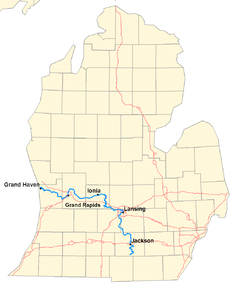
 A map of the Grand River
| |

| |
| Physical characteristics | |
| Source | |
| • location | Somerset Township, Hillsdale County, Michigan |
| • coordinates | 42°05′12″N 84°25′21″W / 42.08670°N 84.42245°W |
| Mouth | |
• location
|
Grand Haven, Michigan |
• coordinates
|
43°03′30″N 86°15′03″W / 43.05835°N 86.25088°W |
| Length | 252 mi (406 km) |
| Basin size | 5,572sq.mi. |
| Discharge | |
| • location | mouth |
| • average | 5,048.87 cu ft/s (142.968 m3/s) (estimate) |
The Grand River is a river in the Lower Peninsula of the U.S. state of Michigan. It is the longest river in Michigan.[1] Its largest city is Grand Rapids.
The river flows in a northwest direction from Hillsdale County into Lake Michigan near the city of Grand Haven. The river flows through a number of cities, including Jackson, Lansing and Ionia.
The original name for the river was "owashtanong", meaning "far-flowing water" in Ottawa.[2][3]
References
[change | change source]- ↑ "National Hydrography Dataset high-resolution flowline data". The National Map. U.S. Geological Survey. Archived from the original on March 29, 2012. Retrieved May 19, 2011.
- ↑ Richmond, Rebecca L. (1906). "The Fur Traders of the Grand River Valley". Publications of the Historical Society of Grand Rapids. 1. Grand Rapids, MI: Historical Society of Grand Rapids: 36. OCLC 13895154.
- ↑ Siegel, Jane (1993). 'A Snug Little Place': Memories of Ada Michigan, 1821–1930. Ada, MI: Ada Historical Society. p. 18. OCLC 29485380.
Other websites
[change | change source] Media related to Grand River (Michigan) at Wikimedia Commons
