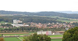
Granges-près-Marnand
Appearance
Granges-près-Marnand | |
|---|---|
 Granges-près-Marnand and Sassel | |
| Coordinates: 46°46′N 6°53′E / 46.767°N 6.883°E | |
| Country | Switzerland |
| Canton | Vaud |
| District | Broye-Vully |
| Area | |
| • Total | 6.95 km2 (2.68 sq mi) |
| Elevation | 473 m (1,552 ft) |
| Population (2009) | |
| • Total | 1,210 |
| • Density | 170/km2 (450/sq mi) |
| Time zone | UTC+01:00 (Central European Time) |
| • Summer (DST) | UTC+02:00 (Central European Summer Time) |
| Postal code(s) | 1523 |
| SFOS number | 5818 |
| Surrounded by | Cheiry (FR), Fétigny (FR), Henniez, Marnand, Ménières (FR), Sassel, Surpierre (FR), Trey, Villeneuve (FR) |
| Website | Profile (in French), SFSO statistics |
Granges-près-Marnand was a municipality in the Broye-Vully district in the canton of Vaud in Switzerland. On 1 July 2011, the former municipalities of Cerniaz, Combremont-le-Grand, Combremont-le-Petit, Granges-près-Marnand, Marnand, Sassel, Seigneux and Villars-Bramard joined together to become the new municipality of Valbroye.[1]
Transport
[change | change source]The municipality has a rail connection to the Léman Express network via the Palézieux–Payerne line. On 29 July 2013, two passenger trains on the line suffered a head-on collision at Granges-près-Marnand, causing at least 35 injuries and one fatality.[2]
References
[change | change source]- ↑ Amtliches Gemeindeverzeichnis der Schweiz published by the Swiss Federal Statistical Office (in German) accessed 17 February 2011
- ↑ "Dozens injured as two trains collide in Switzerland". RTÉ News. Retrieved 29 July 2013.
Other websites
[change | change source] Media related to Granges-près-Marnand at Wikimedia Commons
- Granges-près-Marnand in German, French and Italian in the online Historical Dictionary of Switzerland.


