Hampden, New Zealand
Appearance
Hampden | |
|---|---|
Rural settlement | |
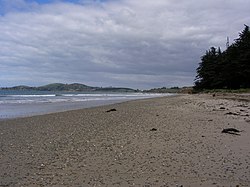
 The beach at Hampden looking south | |
 | |
| Coordinates: 45°19′40″S 170°49′00″E / 45.32778°S 170.81667°E | |
| Country | New Zealand |
| Region | Otago |
| Territorial authority | Waitaki District |
| Ward | Waihemo Ward |
| Community | Waihemo Community |
| Electorates |
|
| Government | |
| • Territorial authority | Waitaki District Council |
| • Regional council | Otago Regional Council |
| • Mayor of Waitaki | Gary Kircher |
| • Waitaki MP | Miles Anderson |
| • Te Tai Tonga MP | Tākuta Ferris |
| Area | |
| • Total | 2.56 km2 (0.99 sq mi) |
| Population (June 2023)[2] | |
| • Total | 370 |
| • Density | 140/km2 (370/sq mi) |
| Time zone | UTC+12 (New Zealand Standard Time) |
| • Summer (DST) | UTC+13 (New Zealand Daylight Time) |
| Postcode | 9410 |
Hampden is a small town in North Otago, New Zealand. It is located on State Highway 1 and is 35 kilometers south of Oamaru and 80 kilometers north of Dunedin. It has a primary school with rectangular grid system and has streets named after English countries.
References
[change | change source]- ↑ "ArcGIS Web Application". statsnz.maps.arcgis.com. Retrieved 28 November 2021.
- ↑ "Subnational population estimates (RC, SA2), by age and sex, at 30 June 1996-2023 (2023 boundaries)". Statistics New Zealand. Retrieved 25 October 2023. (regional councils); "Subnational population estimates (TA, SA2), by age and sex, at 30 June 1996-2023 (2023 boundaries)". Statistics New Zealand. Retrieved 25 October 2023. (territorial authorities); "Subnational population estimates (urban rural), by age and sex, at 30 June 1996-2023 (2023 boundaries)". Statistics New Zealand. Retrieved 25 October 2023. (urban areas)
