Hernando de Soto Bridge
Appearance
Hernando de Soto Bridge | |
|---|---|
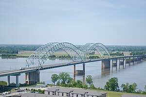
 Hernando de Soto Bridge photographed from the Memphis Pyramid | |
| Coordinates | 35°09′10″N 90°03′50″W / 35.15278°N 90.06389°W |
| Carries | 6 lanes of |
| Crosses | Mississippi River |
| Locale | West Memphis, Arkansas, and Memphis, Tennessee |
| Other name(s) | The M Bridge, Memphis Bridge, Mississippi Bridge, New Bridge |
| Maintained by | TDOT and ARDOT |
| ID number | 79I00400001 |
| Characteristics | |
| Design | tied arch, through arch |
| Material | Steel |
| Pier construction | Concrete |
| Total length | 9,432.6 feet (2,875 m) |
| Width | 90 feet (27 m) |
| Longest span | 900 feet (274 m) |
| Clearance below | 109 feet (33 m) |
| History | |
| Construction start | May 2, 1967 |
| Opened | August 2, 1973 |
| Statistics | |
| Daily traffic | 37,308 (2018)[1] |
| Location | |
 | |
The Hernando de Soto Bridge is a tied-arch bridge carrying Interstate 40 over the Mississippi River between West Memphis, Arkansas, and Memphis, Tennessee. People who live in Memphis also call the bridge the "New Bridge", because it is newer than the Memphis & Arkansas Bridge (carrying Interstate 55) downstream.
References
[change | change source]- ↑ Tennessee Department of Transportation. "Traffic History". ArcGIS. Esri.
