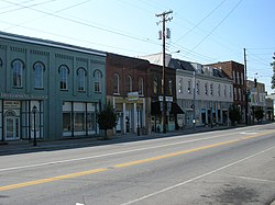
Irvine, Kentucky
Appearance
Irvine, Kentucky | |
|---|---|
 Downtown Irvine | |
| Coordinates: 37°41′49″N 83°58′1″W / 37.69694°N 83.96694°W | |
| Country | United States |
| State | Kentucky |
| County | Estill |
| Named for | William Irvine, an area pioneer |
| Area | |
| • Total | 1.53 sq mi (3.97 km2) |
| • Land | 1.46 sq mi (3.78 km2) |
| • Water | 0.07 sq mi (0.19 km2) |
| Elevation | 679 ft (207 m) |
| Population | |
| • Total | 2,360 |
| • Density | 1,500/sq mi (590/km2) |
| Time zone | UTC-5 (Eastern (EST)) |
| • Summer (DST) | UTC-4 (EDT) |
| ZIP codes | 40336, 40472 |
| Area code | 606 |
| FIPS code | 21-39646 |
| GNIS feature ID | 0512925 |
Irvine (locally /ˈɜːrvən, ˈɜːrvaɪn/) is a home rule-class city[3] in Estill County, Kentucky, in the United States. It is the seat of its county.[4] Its population was 2,360 at the time of the 2020 census.[2] It is near the Kentucky River.
References
[change | change source]- ↑ "2020 U.S. Gazetteer Files". United States Census Bureau. Retrieved March 18, 2022.
- ↑ 2.0 2.1 "Irvine city, Kentucky". United States Census Bureau. Retrieved November 13, 2023.
- ↑ "Summary and Reference Guide to House Bill 331 City Classification Reform" (PDF). Kentucky League of Cities. Retrieved December 30, 2014.
- ↑ "Find a County". National Association of Counties. Archived from the original on 2011-05-31. Retrieved 2011-06-07.


