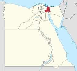
Ismailia Governorate
Appearance
Ismailia Governorate | |
|---|---|
 Ismailia Governorate on the map of Egypt | |
| Country | |
| Seat | Ismailia (capital) |
| Area | |
| • Total | 5,066 km2 (1,956 sq mi) |
| Population (January 2018) | |
| • Total | 1,325,000[2] |
| Time zone | UTC+2 (EET) |
| Website | www |
Ismailia Governorate is a governorate in Egypt. The capital city is also named Ismailia. It was named after Ismail Pasha, who as Ottoman Viceroy of Egypt, oversaw the country during the building of the Suez Canal.[3]
References
[change | change source]- ↑ "About the governorate". www.ismailia.gov.eg. Archived from the original on 13 December 2018. Retrieved 13 December 2018.
- ↑ "Population Estimates By Governorate ( Urban /Rural ) 1/1/2018". www.capmas.gov.eg. Archived from the original on 2018-11-02. Retrieved 10 October 2018.
- ↑ "Ismail-Pasha". Britannica. Archived from the original on 19 October 2016. Retrieved 16 October 2016.


