Itirapina
Appearance
Itirapina | |
|---|---|
 View of center in Itirapina | |
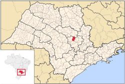
 Location in São Paulo state | |
| Coordinates: 22°15′10″S 47°49′22″W / 22.25278°S 47.82278°W | |
| Country | Brazil |
| Region | Southeast |
| State | São Paulo |
| Area | |
| • Total | 565 km2 (218 sq mi) |
| Population (2020 [1]) | |
| • Total | 18,387 |
| • Density | 33/km2 (84/sq mi) |
| Time zone | UTC−3 (BRT) |
Itirapina is an Brazilian municipality in the state of São Paulo. 18,387 people lived here in 2020 and its area is 565 km2.[2] The elevation is 770 m.
The municipality has 56% of the Itirapina Ecological Station, created in 1984.[3]
References
[change | change source]- ↑ IBGE 2020
- ↑ Instituto Brasileiro de Geografia e Estatística
- ↑ ESEC de Itirapina (in Portuguese), ISA: Instituto Socioambiental, retrieved 2017-02-19[permanent dead link]


