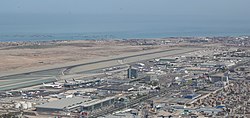
Jorge Chávez International Airport
Jorge Chávez International Airport Aeropuerto Internacional Jorge Chávez | |||||||||||||||
|---|---|---|---|---|---|---|---|---|---|---|---|---|---|---|---|
 | |||||||||||||||
| Summary | |||||||||||||||
| Airport type | Public international | ||||||||||||||
| Operator | Lima Airport Partners | ||||||||||||||
| Serves | Lima, Peru | ||||||||||||||
| Location | Callao, Peru | ||||||||||||||
| Hub for |
| ||||||||||||||
| Focus city for | |||||||||||||||
| Elevation AMSL | 34 m / 113 ft | ||||||||||||||
| Coordinates | 12°01′19″S 077°06′52″W / 12.02194°S 77.11444°W | ||||||||||||||
| Website | www | ||||||||||||||
| Runways | |||||||||||||||
| |||||||||||||||
| Statistics (2020) | |||||||||||||||
| |||||||||||||||
Source: corpac s.a. statistics[1] | |||||||||||||||
Jorge Chávez International Airport (IATA: LIM, ICAO: SPJC, formerly SPIM) (Aeropuerto Internacional Jorge Chávez) is the main air terminal in the Lima metropolitan area.
Location
[change | change source]It is located in the constitutional province of Callao. It is the most important airport in Peru, since it has the majority of international and domestic flights in the country. They serve more than 22,000,000 passengers per year.
Its location in the middle of the west coast of South America has made it an important hub for the subcontinent. It stands out for its enormous projections in the connection of flights between the Americas. This resulted in a sustained growth in the flow of passengers, cargo and mail.
Airlines
[change | change source]It is the center of operations for South America for LATAM with its Peruvian associate LATAM Peru and for Sky Airline with its Peruvian associate Sky Airline Peru.
References
[change | change source]- ↑ Statistics. "CORPAC S.A." www.corpac.gob.pe.
