Kaikohe
Appearance
Kaikohe | |
|---|---|
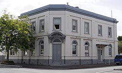
 Bank of New Zealand Building | |
 | |
| Coordinates: 35°24′27″S 173°47′59″E / 35.40750°S 173.79972°E | |
| Country | New Zealand |
| Region | Northland Region |
| District | Far North District |
| Ward | Kaikohe/Hokianga |
| Electorates | |
| Government | |
| • Territorial Authority | Far North District Council |
| • Regional council | Northland Regional Council |
| Area | |
| • Total | 5.68 km2 (2.19 sq mi) |
| Population (June 2023)[2] | |
| • Total | 4,980 |
| • Density | 880/km2 (2,300/sq mi) |
| Postcode(s) | 0405 |

Kaikohe is an inland town in the Far North District, New Zealand. It is situated 260 kilometers from Auckland and 85 kilometers from Whangārei. It has two state highways running through the town State Highway 12 and State Highway 15 running through the town. It has 6 schools including Northland College in the town and former prime minister David Lange was once a resident.
References
[change | change source]- ↑ "ArcGIS Web Application". statsnz.maps.arcgis.com. Retrieved 14 April 2022.
- ↑ "Subnational population estimates (RC, SA2), by age and sex, at 30 June 1996-2023 (2023 boundaries)". Statistics New Zealand. Retrieved 25 October 2023. (regional councils); "Subnational population estimates (TA, SA2), by age and sex, at 30 June 1996-2023 (2023 boundaries)". Statistics New Zealand. Retrieved 25 October 2023. (territorial authorities); "Subnational population estimates (urban rural), by age and sex, at 30 June 1996-2023 (2023 boundaries)". Statistics New Zealand. Retrieved 25 October 2023. (urban areas)
