Kanem (prefecture)
Appearance
(Redirected from Kanem Prefecture)
14°07′10″N 15°18′48″E / 14.1194°N 15.3133°E
Kanem
كانم | |
|---|---|
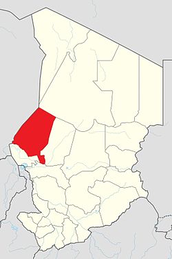
 Map of Chad showing Kanem. | |
| Country | Chad |
| Departments | 3 |
| Sub-prefectures | 10 |
| Regional capital | Mao |
| Government | |
| • Governor | Ngamai Djari (2008) |
| Population (2009) | |
| • Total | 354,603 |
Kanem (Arabic: كانم) was one of fourteen prefectures of Chad. The capital of Kanem was Mao. Since 2002, Chad is divided into regions.
| |||
|
Batha · Biltine · Borkou-Ennedi-Tibesti · Chari-Baguirmi · Guéra · Kanem · Lac · Logone Occidental · Logone Oriental · Mayo-Kébbi · Moyen-Chari · Ouaddaï · Salamat · Tandjilé · | |||
|
See also : Regions of Chad - Departments of Chad |
