Kayin State
Kayin State
ဖၠုံခါန်ႋကၞင့် | |
|---|---|
| ကရင်ပြည်နယ် | |
| Other transcription(s) | |
| • Karen | k'nyaw kawseh |
| • Burmese | ka.rang pranynai |
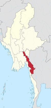
 Location of Kayin State in Myanmar | |
| Coordinates: 17°0′N 97°45′E / 17.000°N 97.750°E | |
| Country | |
| Region | Southeast |
| Capital | Hpa-An |
| Government | |
| • Chief Minister | Saw Myint Oo |
| • Cabinet | Kayin State Government |
| Area | |
| • Total | 30,382.8 km2 (11,730.9 sq mi) |
| • Rank | 11th |
| Highest elevation (Nattaung) | 2,623 m (8,606 ft) |
| Population | |
| • Total | 1,574,079 |
| • Rank | 11th |
| • Density | 52/km2 (130/sq mi) |
| Demonym(s) | Karen, Kayin |
| Demographics | |
| • Ethnicities | Karen (majority), Padaung, Bamar, Shan, Pa-O, Mon, Rakhine, Burmese-Thai |
| Time zone | UTC+06:30 (MMT) |
| HDI (2017) | 0.527[2] low · 12th |
| Official language | Karen |
| Website | www |
Kayin State (Eastern Pwo: ဖၠုံခါန်ႋကၞင့်; S'gaw Karen: ကညီကီၢ်စဲၣ်, pronounced [kɲɔkɔshæ], Burmese: ကရင်ပြည်နယ်, pronounced: [kəjɪ̀ɴ pjìnɛ̀]), also known by its former name Karen State, is a state of Myanmar. The capital city is Hpa-An, also spelled Pa-An.
Government
[change | change source]The government of Kayin State is split into three branches: an executive (Kayin State Government), a legislative (Kayin State Hluttaw), and a judicial (Kayin State High Court).
Administrative divisions
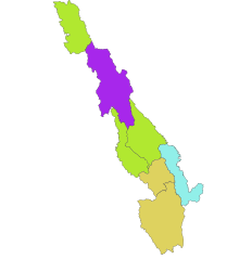
[change | change source]Karen State has one city and nine towns. It has four districts, seven townships and 4092 villages.

Districts
[change | change source]- Hpa-an District
- Myawaddy District
- Kawkareik District
- Hpapun District
- Kyondoe District
Townships
[change | change source]- Hpa-an Township
- Hlaingbwe Township
- Hpapun Township
- Thandaunggyi Township
- Myawaddy Township
- Kawkareik Township
- Kyainseikgyi Township
Cities and towns
[change | change source]
Villages and hamlets
[change | change source]Kayin State is very mountainous so the villages are very small. Lots of Kayin State's population is across the countryside in hundreds of villages.
Population
[change | change source]| Year | Pop. | ±% |
|---|---|---|
| 1973 | 858,429 | — |
| 1983 | 1,055,359 | +22.9% |
| 2014 | 1,574,079 | +49.2% |
| Source: 2014 Myanmar Census[1] | ||
Since the 1973 Census, the population of Karen State has increased from 858,429 to 1,055,359 in the 1983 census and 1,574,079 in the census of 2014.[3]
Transport
[change | change source]Karen State has two airports, Hpapun Airport and Hpa-An Airport, but they aren't open to the public currently.
References
[change | change source]- ↑ 1.0 1.1 Census Report. The 2014 Myanmar Population and Housing Census. Vol. 2. Naypyitaw: Ministry of Immigration and Population. May 2015. p. 17.
- ↑ "Sub-national HDI - Area Database - Global Data Lab". hdi.globaldatalab.org. Retrieved 2018-09-13.
- ↑ The 2014 Myanmar Population and Housing Census: Kayin State. Nay Pyi Taw: Ministry of Immigration and Population. 2015. p. 11.


