Kent, Washington
Appearance
Kent, Washington | |
|---|---|
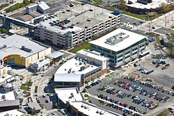
 Kent Station, Kent Regional Library (top right) and Kent Sounder Station in 2009 | |
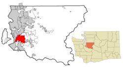
 Location of Kent in King County, Washington | |
| Coordinates: 47°22′58″N 122°13′37″W / 47.38278°N 122.22694°W | |
| Country | United States |
| State | Washington |
| County | King |
| Incorporated | May 28, 1890 |
| Government | |
| • Type | Mayor–council |
| Area | |
| • Total | 34.42 sq mi (89.14 km2) |
| • Land | 33.75 sq mi (87.41 km2) |
| • Water | 0.67 sq mi (1.73 km2) |
| Elevation | 43–500 ft (13−152 m) |
| Population | |
| • Total | 136,588 |
| • Rank | US: 206th WA: 6th |
| • Density | 4,000/sq mi (1,500/km2) |
| Time zone | UTC-8 (PST) |
| • Summer (DST) | UTC-7 (PDT) |
| ZIP codes | List
|
| Area code | 253 |
| FIPS code | 53-35415 |
| GNIS feature ID | 1530952[3] |
| Website | kentwa.gov |
Kent is a city in King County, Washington, United States. It is the sixth largest city in the state. Kent part of the Seattle–Tacoma metropolitan area. It is located 19 miles south of Seattle and 19 miles northeast of Tacoma.[4]
Kent's population as of April 2020 was 136,588 according to the 2020 census.[2]
References
[change | change source]- ↑ "2019 U.S. Gazetteer Files". United States Census Bureau. Retrieved August 7, 2020.
- ↑ 2.0 2.1 "QuickFacts: Kent city, Washington". United States Census Bureau. Retrieved March 20, 2024.
- ↑ "Kent". Geographic Names Information System. United States Geological Survey.
- ↑ "Kent is incorporated on May 28, 1890". historylink.org. History Ink. Retrieved July 29, 2015.


