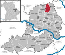
Konzell
Appearance
Konzell | |
|---|---|
 Church of Saint Martin | |
| Coordinates: 49°4′N 12°43′E / 49.067°N 12.717°E | |
| Country | Germany |
| State | Bavaria |
| Admin. region | Niederbayern |
| District | Straubing-Bogen |
| Government | |
| • Mayor (2020–26) | Hans Kienberger[1] (CSU) |
| Area | |
| • Total | 26.76 km2 (10.33 sq mi) |
| Highest elevation | 900 m (3,000 ft) |
| Lowest elevation | 500 m (1,600 ft) |
| Population (2022-12-31)[2] | |
| • Total | 1,835 |
| • Density | 69/km2 (180/sq mi) |
| Time zone | UTC+01:00 (CET) |
| • Summer (DST) | UTC+02:00 (CEST) |
| Postal codes | 94357 |
| Dialling codes | 09963 |
| Vehicle registration | SR |
| Website | www.konzell.de |
Konzell is a municipality in Straubing-Bogen in Bavaria, Germany.
Geography
[change | change source]Konzell is in the south of the Bavarian Forest. Here is the spring of the Menach, which flows in the valley of Menach direction the Bogen.
Mountains
[change | change source]The Gallner Berg to the south, the western peak of the Gallner, and the Kramerschopf to the east are the highest points, each reaching 710 metres. To the north is the Himmelberg at 680 metres.
Urban districts
[change | change source]To Konzell belong the urban districts Auggenbach, Denkzell, Gossersdorf and Kasparzell.
Gallery
[change | change source]-
Rectory
-
Primary school
-
fountain near school and church
-
Brewerie (Klett-Bräu)
References
[change | change source]- ↑ Liste der ersten Bürgermeister/Oberbürgermeister in kreisangehörigen Gemeinden, Bayerisches Landesamt für Statistik, 15 July 2021.
- ↑ Genesis Online-Datenbank des Bayerischen Landesamtes für Statistik Tabelle 12411-003r Fortschreibung des Bevölkerungsstandes: Gemeinden, Stichtag (Einwohnerzahlen auf Grundlage des Zensus 2011) .


