Kottangal
Appearance
Kottangal | |
|---|---|
Village | |
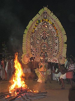
 A depiction of Paala Bhairavi in Kottangal padayani | |
| Coordinates: 9°27′0″N 76°44′0″E / 9.45000°N 76.73333°E | |
| Country | |
| State | Kerala |
| District | Pathanamthitta |
| Panchayat | Kottangal |
| Named for | Kottangal padayani |
| Government | |
| • Type | Panchayath |
| Area | |
| • Total | 23.08 km2 (8.91 sq mi) |
| Population (2001) | |
| • Total | 17,484[1] |
| • Density | 735/km2 (1,900/sq mi) |
| Languages | |
| • Official | Malayalam, English |
| Time zone | UTC+5:30 (IST) |
| Vehicle registration | KL-28, KL-62 |
| Literacy | 96.51% |
| Nearest cities | Mallappally, Ranni |
| Website | [1] |
Kottangal is a village in Pathanamthitta district, Kerala state,India.[2]
Language
[change | change source]Malayalam is the native language of Kottangal.
Politics
[change | change source]Kottangal is a part of Pathanamthitta Loksabha constituency. Mr. Anto Antony is the current Member of Parliament of the constituency.
Weather
[change | change source]The climate of the place is moderate and pleasant. Tropical climate is prevailed here throughout the year.
Transportation
[change | change source]The major transportation service of this place is provided by Kerala State Road Transport Corporation (KSRTC).
References
[change | change source]- ↑ "Census of India". Archived from the original on 3 April 2007. Retrieved 2008-03-11.
- ↑ "Census of India : Villages with population 5000 & above". Registrar General & Census Commissioner, India. Archived from the original on 8 December 2008. Retrieved 2008-12-10.


