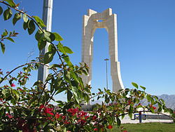
Lar, Iran
Appearance
Lar
لار | |
|---|---|
City | |
 | |
| Coordinates: 27°40′52″N 54°20′25″E / 27.68111°N 54.34028°E | |
| Country | |
| Province | Fars |
| County | Larestan |
| Bakhsh | Central |
| Area | |
| • Total | 5,000 km2 (2,000 sq mi) |
| Elevation | 802 m (2,631 ft) |
| Population (2016 Census) | |
| • Total | 62,045 [1] |
| Time zone | UTC+3:30 (IRST) |
| • Summer (DST) | UTC+4:30 (IRDT) |
| Area code | 0715 |
Lar (Persian: لار, also Romanized as Lār; also known as Larestan)[2] is a city and capital of Larestan County, Fars Province, Iran.
References
[change | change source]- ↑ "Statistical Centre of Iran > Home".
- ↑ Lar, Iran can be found at GEOnet Names Server, at this link, by opening the Advanced Search box, entering "-3072906" in the "Unique Feature Id" form, and clicking on "Search Database".


