Lena River
| Lena | |
|---|---|
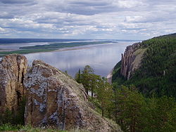
 The Lena Pillars along the river near Yakutsk | |
 Lena watershed | |
| Location | |
| Country | Russia |
| Physical characteristics | |
| Source | Baikal Mountains, Irkutsk Oblast |
| - coordinates | 53°58′3″N 107°52′56″E / 53.96750°N 107.88222°E (approximately) |
| - elevation | 1,640 m (5,380 ft) |
| Mouth | Lena Delta |
| - location | Arctic Ocean, Laptev Sea |
| - coordinates | 72°24′31″N 126°41′05″E / 72.4087°N 126.6847°E |
| Length | 4,294 km (2,668 mi) |
| Basin size | 2,460,742 km2 (950,098 sq mi) 2,490,000 km2 (960,000 sq mi) |
| Discharge | Lena Delta, Laptev Sea, Russia
Multiannual discharge [5] (Period of data: 1984-2018)577 km3/a (18,300 m3/s)[6] 1999-2008: 581 km3/a (18,400 m3/s) 1990-2006: 362 km3/a (11,500 m3/s) 2004-2006: 615 km3/a (19,500 m3/s) 2018-2019: 690 km3/a (22,000 m3/s) 1940-2017: 542 km3/a (17,200 m3/s)[7] 1940-2019: 545.7 km3/a (17,290 m3/s) |
| - location | Kyusyur, Russia (Basin size: 2,440,000 km2 (940,000 sq mi); 2,418,974 km2 (933,971 sq mi)[1] |
| - average | (Period of data: 1971-2015)17,773 m3/s (627,600 cu ft/s)[2]
(Period of data: 1970-1999)17,067 m3/s (602,700 cu ft/s)[3] 15,500 m3/s (550,000 cu ft/s)[4] |
| - minimum | 366 m3/s (12,900 cu ft/s) |
| - maximum | 241,000 m3/s (8,500,000 cu ft/s) |
| Discharge | |
| - location | Kirensk |
| - average | 480 m3/s (17,000 cu ft/s) |
| Discharge | |
| - location | Vitim |
| - average | 1,700 m3/s (60,000 cu ft/s) |
| Discharge | |
| - location | Olyokminsk |
| - average | 4,500 m3/s (160,000 cu ft/s) |
| Discharge | |
| - location | Vilyuy inflow |
| - average | 12,100 m3/s (430,000 cu ft/s) |
| Basin features | |
| Tributaries | |
| - left | Vilyuy |
| - right | Kirenga, Vitim, Olyokma, Aldan |

The Lena River is a river in Siberia, flowing into the Arctic Ocean. With a length of 4,472 km (2,779 mi), it is the tenth longest river in the world. With a watershed size of 250,000,000,000,000,000 km2 (9.7×10¹⁶ sq mi), it has the nineth largest watershed.
The Lena begins in the Baikal Mountains, a mountain range in central Siberia, at a point 11 km (6.8 mi) west of Lake Baikal. The Lena flows northeast. Some of its major tributaries are the Kirenga, Vitim, Oylokma, Aldan, and Vilyuy rivers. It empties into the Laptev Sea, a branch of the Arctic Ocean.
The name "Lena" comes from the word, Elyu-Ene, meaning "The Large River". The word comes from the Evenks, a people of Northern Asia.
Sources
[change | change source]- ↑ Stadnyk, Tricia A.; Tefs, A.; Broesky, M.; Déry, S. J.; Myers, P. G.; Ridenour, N. A.; Koenig, K.; Vonderbank, L.; Gustafsson, D. (2021). "Changing freshwater contributions to the Arctic". Elementa: Science of the Anthropocene. 9. doi:10.1525/elementa.2020.00098. S2CID 236682638.
- ↑ Stadnyk, Tricia A.; Tefs, A.; Broesky, M.; Déry, S. J.; Myers, P. G.; Ridenour, N. A.; Koenig, K.; Vonderbank, L.; Gustafsson, D. (2021). "Changing freshwater contributions to the Arctic". Elementa: Science of the Anthropocene. 9. doi:10.1525/elementa.2020.00098. S2CID 236682638.
- ↑ https://www.iwp.ru/upload/medialibrary/6a1/6a16cca9b59251ad80a7945d9acb5ef6.pdf.
{{cite web}}: Missing or empty|title=(help) - ↑ http://www.abratsev.narod.ru/biblio/sokolov/p1ch23b.html, Sokolov, Eastern Siberia // Hydrography of USSR. (in russian)
- ↑ "Archived copy". Archived from the original on 2022-10-16. Retrieved 2022-10-16.
{{cite web}}: CS1 maint: archived copy as title (link) - ↑ Stadnyk, Tricia A.; Tefs, A.; Broesky, M.; Déry, S. J.; Myers, P. G.; Ridenour, N. A.; Koenig, K.; Vonderbank, L.; Gustafsson, D. (2021). "Changing freshwater contributions to the Arctic". Elementa: Science of the Anthropocene. 9. doi:10.1525/elementa.2020.00098. S2CID 236682638.
- ↑ "River Discharge". Archived from the original on 2021-09-21. Retrieved 2022-10-16.
Other websites
[change | change source]![]() Media related to Lena River at Wikimedia Commons
Media related to Lena River at Wikimedia Commons
