Leonding
Appearance
Leonding | |
|---|---|
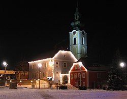
 Saint Michael's church, Leonding | |
| Coordinates: 48°16′0″N 14°15′0″E / 48.26667°N 14.25000°E | |
| Country | Austria |
| State | Upper Austria |
| District | Linz-Land |
| Government | |
| • Mayor | Walter Brunner (SPÖ) |
| Area | |
| • Total | 24.04 km2 (9.28 sq mi) |
| Elevation | 289 m (948 ft) |
| Population (2018-01-01)[2] | |
| • Total | 28,698 |
| • Density | 1,200/km2 (3,100/sq mi) |
| Time zone | UTC+1 (CET) |
| • Summer (DST) | UTC+2 (CEST) |
| Postal code | 4060 |
| Area code | 0732 |
| Vehicle registration | LL |
| Website | www.leonding.at |
Leonding is a city southwest of Linz in the Austrian state of Upper Austria, in Austria. In 2001, about 22,269 people lived in Leonding. It covers an area of 24.05 km² (9.28 mi²). It borders Puchenau and the river Danube in the north, Wilhering and Pasching in the west, Traun in the south and Linz in the east.
Adolf Hitler lived in Leonding between 1898 and 1905, and attended the school there.
References
[change | change source]- ↑ "Dauersiedlungsraum der Gemeinden Politischen Bezirke und Bundesländer - Gebietsstand 1.1.2018". Statistics Austria. Retrieved 10 March 2019.
- ↑ "Einwohnerzahl 1.1.2018 nach Gemeinden mit Status, Gebietsstand 1.1.2018". Statistics Austria. Retrieved 9 March 2019.
Other websites
[change | change source]Wikimedia Commons has media related to Leonding.
- (in German) Official Homepage Archived 2021-05-06 at the Wayback Machine


