List of districts of Telangana
Appearance

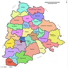
The state of Telangana, in southern India is divided into 31 districts. A 'district' in the state of Telangana is an administrative geographical unit, headed by a District collector, an officer belonging to the Indian Administrative Service.
Statistics
[change | change source]
In terms of area, Bhadradri Kothagudem is the largest district with an area of 7,483 km2 (2,889 sq mi) and Hyderabad is the smallest with 217 km2 (84 sq mi). Hyderabad district is the most populated district with a population of 3943323 and Kumarambheem Asifabad district is the least populated with 515,805.[1]
District statistics
[change | change source]| S.No. | Name | Headquarters | Area (km2) | Population (2011 census) |
No.of mandals | Density (per km2) |
Urban (%) | Literacy (%) | Sex Ratio |
|---|---|---|---|---|---|---|---|---|---|
| 1 | Adilabad | Adilabad | 4,153 | 708,972 | 18 | 171 | 23.66 | 63.46 | 989 |
| 2 | Bhadradri Kothagudem | Kothagudem | 7,483 | 1,069,261 | 23 | 143 | 31.71 | 66.40 | 1008 |
| 3 | Hyderabad | Hyderabad | 217 | 3,943,323 | 16 | 18172 | 100 | 83.25 | 954 |
| 4 | Jagtial | Jagtial | 2,419 | 985,417 | 18 | 407 | 22.46 | 60.26 | 1036 |
| 5 | Jangaon | Jangaon | 2,188 | 566,376 | 13 | 259 | 12.60 | 61.44 | 997 |
| 6 | Jayashankar Bhupalapally | Bhupalpalle | 6,175 | 711,434 | 20 | 115 | 7.57 | 60.33 | 1009 |
| 7 | Jogulamba Gadwal | Gadwal | 2,928 | 609,990 | 12 | 208 | 10.36 | 49.87 | 972 |
| 8 | Kamareddy | Kamareddy | 3,652 | 972,625 | 22 | 266 | 12.71 | 56.51 | 1033 |
| 9 | Karimnagar | Karimnagar | 2,128 | 1,005,711 | 16 | 473 | 30.72 | 69.16 | 993 |
| 10 | Khammam | Khammam | 4,361 | 1,401,639 | 21 | 321 | 22.60 | 65.95 | 1005 |
| 11 | Kumarambheem Asifabad | Asifabad | 4,878 | 515,812 | 15 | 106 | 16.86 | 56.72 | 998 |
| 12 | Mahabubabad | Mahabubabad | 2,877 | 774,549 | 16 | 269 | 9.86 | 57.13 | 996 |
| 13 | Mahabubnagar | Mahabubnagar | 5,285 | 1,486,777 | 26 | 281 | 20.73 | 56.78 | 995 |
| 14 | Mancherial | Mancherial | 4,016 | 807,037 | 18 | 201 | 43.85 | 64.35 | 977 |
| 15 | Medak | Medak | 2,786 | 767,428 | 20 | 275 | 7.67 | 56.12 | 1027 |
| 16 | Medchal–Malkajgiri[2] | Medchal | 1,084 | 2,440,073 | 14 | 2251 | 91.40 | 82.49 | 957 |
| 17 | Nagarkurnool | Nagarkurnool | 6,924 | 861,766 | 20 | 124 | 10.19 | 54.38 | 968 |
| 18 | Nalgonda | Nalgonda | 7,122 | 1,618,416 | 31 | 227 | 22.76 | 63.75 | 978 |
| 19 | Nirmal | Nirmal | 3,845 | 709,418 | 19 | 185 | 21.38 | 57.77 | 1046 |
| 20 | Nizamabad | Nizamabad | 4,288 | 1,571,022 | 27 | 366 | 29.58 | 64.25 | 1044 |
| 21 | Peddapalli | Peddapalli | 2,236 | 795,332 | 14 | 356 | 38.22 | 65.52 | 992 |
| 22 | Rajanna Sircilla | Sircilla | 2,019 | 552,037 | 13 | 273 | 21.17 | 62.71 | 1014 |
| 23 | Ranga Reddy | Shamshabad | 5,031 | 2,446,265 | 27 | 486 | 58.05 | 71.95 | 950 |
| 24 | Sangareddy | Sangareddi | 4,403 | 1,527,628 | 26 | 347 | 34.69 | 64.08 | 965 |
| 25 | Siddipet | Siddipet | 3,632 | 1,012,065 | 22 | 279 | 13.74 | 61.61 | 1008 |
| 26 | Suryapet | Suryapet | 3,607 | 1,099,560 | 23 | 305 | 15.56 | 64.11 | 996 |
| 27 | Vikarabad[3] | Vikarabad | 3,386 | 927,140 | 18 | 274 | 13.48 | 57.91 | 1001 |
| 28 | Wanaparthy | Wanaparthy | 2,152 | 577,758 | 14 | 268 | 15.97 | 55.67 | 960 |
| 29 | Warangal Rural | Warangal | 2,175 | 718,537 | 15 | 330 | 6.99 | 61.26 | 994 |
| 30 | Warangal Urban | Warangal | 1,309 | 1,080,858 | 11 | 826 | 68.51 | 76.17 | 997 |
| 31 | Yadadri Bhuvanagiri | Bhongir | 3,092 | 739,448 | 16 | 239 | 16.66 | 65.53 | 973 |
| Telangana | - | - | 112,077 | 35,003,674 | 584 | 312 | 38.88 | 66.54 | 988 |
References
[change | change source]- ↑ "::Know Your District - Plan Your District::". Archived from the original on 2017-07-08. Retrieved 2017-09-25.
- ↑ "Medchal-Malkajgiri district" (PDF). Official website of Medchal district. Archived from the original (PDF) on 22 March 2017. Retrieved 20 March 2017.
- ↑ "Vikarabad district". Official website Vikarabad district. Archived from the original on 31 March 2017. Retrieved 31 March 2017.
