Los Banos, California
Appearance
Los Banos, California
Los Baños | |
|---|---|
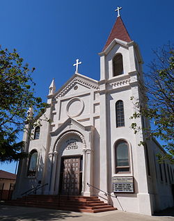
 The Falasco Arts Center, housed in the historic St. Joseph's Church, Los Banos | |
 Location in Merced County and the state of California | |
| Coordinates: 37°03′30″N 120°51′00″W / 37.05833°N 120.85000°W | |
| Country | |
| State | |
| County | Merced |
| Incorporated | May 8, 1907[1] |
| Area | |
| • Total | 10.12 sq mi (26.2 km2) |
| • Land | 10.00 sq mi (25.9 km2) |
| • Water | 0.12 sq mi (0.3 km2) 1.22% |
| Elevation | 118 ft (35 m) |
| Population | |
| • Total | 45,532 |
| • Density | 4,500/sq mi (1,700/km2) |
| Time zone | UTC−8 (Pacific) |
| • Summer (DST) | UTC−7 (PDT) |
| ZIP Code | 93635 |
| Area code | 209 |
| FIPS code | 06-44028 |
| GNIS feature IDs | 277547, 2410878 |
| Website | www |
Los Banos is a city in Merced County, California, United States. The name is Spanish for "the baths".
References
[change | change source]- ↑ "California Cities by Incorporation Date". California Association of Local Agency Formation Commissions. Archived from the original (Word) on February 21, 2013. Retrieved August 25, 2014.
- ↑ "2021 U.S. Gazetteer Files: California". United States Census Bureau. Retrieved August 25, 2022.
- ↑ "Los Banos". Geographic Names Information System. United States Geological Survey.
- ↑ "P1. Race – Los Banos city, California: 2020 DEC Redistricting Data (PL 94-171)". U.S. Census Bureau. Retrieved August 25, 2022.


