Luxembourg City
Luxembourg
Luxembourg / Lëtzebuerg / Luxemburg | |
|---|---|
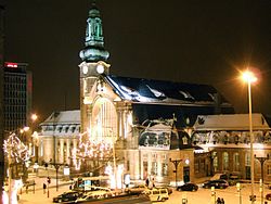
 The main railway station in Luxembourg | |
Map showing, in orange, Luxembourg | |
| Coordinates: 49°36′36″N 6°07′40″E / 49.61000°N 6.12778°E | |
| Country | Luxembourg |
| District | Luxembourg |
| Canton | Luxembourg |
| Commune | Luxembourg |
| Government | |
| • Mayor | Lydie Polfer (DP) |
| Area | |
| • Total | 51.7 km2 (20.0 sq mi) |
| Highest elevation | 408 m (1,339 ft) |
| Lowest elevation | 232 m (761 ft) |
| Population (2016)[1] | |
| • Total | 115,227 |
| • Density | 2,200/km2 (5,800/sq mi) |
| Time zone | UTC+1 (CET) |
| • Summer (DST) | UTC+2 (CEST) |
| LAU2 | LU00011001 |
| Website | Official website |
The city of Luxembourg (Luxembourgish: Lëtzebuerg, French: Luxembourg, German: Luxemburg), also known as Luxembourg City (Luxembourgish: Stad Lëtzebuerg, French: Ville de Luxembourg, German: Stadt Luxemburg), is a commune with city status, and the capital of the Grand Duchy of Luxembourg.
The city is at the confluence of the Alzette and Pétrusse rivers in southern Luxembourg. In the city is found the Luxembourg Castle, built by the Franks in the Early Middle Ages, around which a settlement developed.
History
[change | change source]
During the Roman period, two main roads crossed the territory of the present city of Luxembourg; these two roads met at the place Marché-aux-Poissons (now a street and a neighborhood) dominated by a fortified tower. A castle was built here called Lucilinburhuc ("small castle"). In 963, this place became a property of Siegfried I, a close relative of the Emperors of Germany and Kings of France. Siegfried built a castle, not far from the "Lucilinburhuc" castle, on a rocky cliff called the Bock (Luxembourgish: Bockfiels). This place is now considered the birthplace of the city, the country and the nation.[2]
In 1994 UNESCO named the Old Quarters and Fortifications a World Heritage Site.[3]
Geography
[change | change source]
The city of Luxembourg has an area of 51.73 km2 (20.0 sq mi), about 2% of the territory of the whole country. The altitude varies between 232 m (761 ft) high (Beggen, Bastogne street) and 408 m (1,339 ft) high (Dommeldange); it is 304 m (997 ft) high at the centre of the city.[4]
Luxembourg's climate is on the boundary of oceanic (Cfb in the Koeppen climate classification) and humid continental (Dfb) climates.
Population
[change | change source]As of 1 January 2016[update], there are 115,227 persons living in the commune,[1] for a population density of 2,227.5 inhabitants/km².
Twin cities
[change | change source] Camden, United Kingdom, since 2007
 Metz, France,
 Tambov, Russia, since 2012
 Prague, Czech Republic, since 2012
References
[change | change source]- ↑ 1.0 1.1 "Population by canton and municipality 1821 - 2016". Statistics Portal - Grand Duchy of Luxembourg. Archived from the original on 19 June 2021. Retrieved 6 June 2016.
- ↑ "Histoire de la ville" (in French). Ville de Luxembourg. Archived from the original on 2 March 2013. Retrieved 5 May 2014.
- ↑ "City of Luxembourg: its Old Quarters and Fortifications". UNESCO. Retrieved 8 May 2017.
- ↑ "La ville en chiffres" (in French). Ville de Luxembourg. Archived from the original on 25 June 2014. Retrieved 5 May 2014.
Other websites
[change | change source]- (in French) Ville de Luxembourg - Official website

