Magdalena River
Appearance
| Magdalena | |
|---|---|
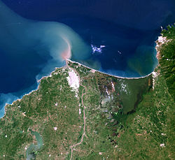
 The delta of the Magdalena River | |
 Map of the Magdalena River watershed | |
| Etymology | Biblical figure Mary Magdalene |
| Location | |
| Country | Colombia |
| Cities | |
| Physical characteristics | |
| Source | La Magdalena lagoon |
| - location | Colombian Massif, Colombia |
| - coordinates | 1°56′3″N 76°36′29″W / 1.93417°N 76.60806°W |
| - elevation | 3,685 m (12,090 ft) |
| Mouth | Caribbean Sea |
| - location | Barranquilla, Colombia |
| - coordinates | 11°7′0″N 74°51′0″W / 11.11667°N 74.85000°W |
| - elevation | 0 m (0 ft) |
| Length | 1,528 km (949 mi)[1] |
| Basin size | 257,438 km2 (99,397 sq mi) |
| Discharge | |
| - location | Calamar, Bolívar[2] |
| - average | 7,200 m3/s (250,000 cu ft/s)[2] |
| - minimum | 2,000 m3/s (71,000 cu ft/s) |
| - maximum | 12,000 m3/s (420,000 cu ft/s) |
| Basin features | |
| Tributaries | |
| - left | Páez River, Saldaña River, La Miel River, Nare River, Cauca River, San Jorge River |
| - right | Cabrera River, Bogotá River, Negro River, Carare River, Sogamoso River, Cesar River |
| Official name | Sistema Delta Estuarino del Río Magdalena, Ciénaga Grande de Santa Marta |
| Designated | 18 June 1998 |
| Reference no. | 951[3] |
The Magdalena River is the most important river in the western part of Colombia. It has a length of 1,538 kilometres (956 mi). Its course is from south to north. About 80 percent of the population of Colombia live on the banks of the river or one of its tributaries. Barranquilla, Colombia's biggest city, lies on the banks of the river.
Watercraft can travel on the river up to the city of Honda, about 1,000 kilometres (620 mi) upstream. At Honda, there are rapids. After these rapids, watercraft can travel for another 240 kilometres (150 mi).
References
[change | change source]- ↑ "Sistema de informacion Ambiental de Colombia – SIAC" (in Spanish). Archived from the original on 2012-03-15. Retrieved 2011-07-13.
- ↑ 2.0 2.1 "Chapter 14" (PDF). The Pacific and Caribbean Rivers of Colombia: Water Discharge, Sediment Transport and Dissolved Loads. Archived from the original (PDF) on 2012-03-25. Retrieved 2011-07-13.
- ↑ "Sistema Delta Estuarino del Río Magdalena, Ciénaga Grande de Santa Marta". Ramsar Sites Information Service. Retrieved 25 April 2018.
