Mankato, Minnesota
Appearance
Mankato, Minnesota | |
|---|---|
 North Riverfront Drive Commercial District | |
| Nickname: Key City | |
| Motto: Leading the way... | |
 | |
| Coordinates: 44°10′N 94°0′W / 44.167°N 94.000°W | |
| Country | United States |
| State | Minnesota |
| Counties | Blue Earth, Nicollet, and Le Sueur |
| Founded | 1852 |
| Government | |
| • Type | City charter |
| Area | |
| • City | 19.77 sq mi (51.20 km2) |
| • Land | 19.43 sq mi (50.33 km2) |
| • Water | 0.34 sq mi (0.87 km2) |
| Elevation | 1,007 ft (307 m) |
| Population | |
| • City | 44,488 |
| • Density | 2,289.54/sq mi (883.99/km2) |
| • Urban | 60,206 (US: 453rd) |
| • Metro | 103,566 (US: 356th) |
| Demonym | Mankatoans |
| Time zone | UTC-6 (Central) |
| • Summer (DST) | UTC-5 (CDT) |
| ZIP codes | 56001-56003 |
| Area code | 507 |
| FIPS code | 27-39878 |
| GNIS feature ID | 2395831[2] |
| Website | mankatomn.gov |
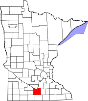
Mankato is a city in Blue Earth and Nicollet counties of Minnesota in the United States. It is the county seat of Blue Earth County. About 44,500 people were living in Mankato as of 2020. It can be found by the Minnesota River where it meets up with the Blue Earth River. It has a sister city called North Mankato. The city of Skyline can be found inside of Mankato.
References
[change | change source]- ↑ "2020 U.S. Gazetteer Files". United States Census Bureau. Retrieved July 24, 2022.
- ↑ 2.0 2.1 U.S. Geological Survey Geographic Names Information System: Mankato, Minnesota
- ↑ "QuickFacts: Mankato city, Minnesota". United States Census Bureau. Retrieved February 21, 2024.
Other websites
[change | change source]- ci.mankato.mn.us Archived 2009-02-11 at the Wayback Machine — City of Mankato
Wikimedia Commons has media related to Mankato, Minnesota.


