Maritime Alps
Appearance
| Maritime Alps | |
|---|---|
| French: Alpes Maritimes Italian: Alpi Marittime | |
 Maritime Alps | |
| Highest point | |
| Peak | Monte Argentera |
| Elevation | 3,297 m (10,817 ft) |
| Coordinates | 44°10′45″N 7°18′18″E / 44.17917°N 7.30500°E |
| Geography | |
| Countries | France, Italy and Monaco |
| Regions, Régions | Piedmont, Liguria and Provence-Alpes-Côte d'Azur |
| Rivers | Verdon, Ubaye, Roya, Var and Stura di Demonte |
| Range coordinates | 44°13.9′N 7°10.6′E / 44.2317°N 7.1767°E |
| Parent range | Alps |
| Borders on | Ligurian Alps, Cottian Alps, Provence Alps and Prealps and Mediterranean Sea |
| Geology | |
| Orogeny | Alpine orogeny |
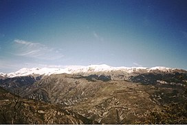
The Maritime Alps (French: Alpes Maritimes [alp maʁitim]; Italian: Alpi Marittime [ˈalpi maˈrittime]) are a mountain range in the southwestern part of the Alps.
They form the border between the French region of Provence-Alpes-Côte d'Azur and the Italian regions of Piedmont and Liguria. They are the southernmost part of the Alps.
Maps
[change | change source]- Italian official cartography (Istituto Geografico Militare - IGM); on-line version: www.pcn.minambiente.it
- French official cartography (Institut Géographique National - IGN); on-line version: www.geoportail.fr Archived 2007-11-13 at the Wayback Machine
