Markleeville, California
Appearance
Markleeville | |
|---|---|
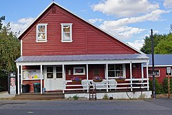
 General Store | |
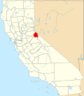
 Location in Alpine County and the state of California | |
| Coordinates: 38°41′42″N 119°46′49″W / 38.69500°N 119.78028°W | |
| Country | |
| State | |
| County | Alpine |
| Area | |
| • Total | 6.531 sq mi (16.915 km2) |
| • Land | 6.531 sq mi (16.915 km2) |
| • Water | 0 sq mi (0 km2) 0% |
| Elevation | 5,531 ft (1,686 m) |
| Population (2020)[2] | |
| • Total | 191 |
| • Density | 29/sq mi (11/km2) |
| Time zone | UTC-8 (Pacific (PST)) |
| • Summer (DST) | UTC-7 (PDT) |
| ZIP code | 96120 |
| Area code | 530 |
| FIPS code | 06-45988 |
| GNIS feature IDs | 1659065, 2408184 |
Markleeville (formerly, Markleville) is a census-designated place (CDP) in California, United States. It is the county seat of Alpine County. The population was 191 at the 2020 census.[2]
References
[change | change source]- ↑ U.S. Census Archived 2012-01-25 at the Wayback Machine
- ↑ 2.0 2.1 "Markleeville CDP, California". United States Census Bureau. Retrieved August 29, 2023.


