Millerton, New York
Appearance
Millerton, New York | |
|---|---|
| Village of Millerton | |
 Business district in Millerton | |
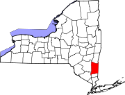
 Location of Millerton, New York | |
| Coordinates: 41°57′14″N 73°30′28″W / 41.95389°N 73.50778°W | |
| Country | United States |
| State | New York |
| County | Dutchess |
| Town | North East |
| Incorporated | 1875 |
| Area | |
| • Total | 0.62 sq mi (1.60 km2) |
| • Land | 0.62 sq mi (1.60 km2) |
| • Water | 0.00 sq mi (0.01 km2) |
| Elevation | 709 ft (216 m) |
| Population | |
| • Total | 903 |
| • Density | 1,465.91/sq mi (565.64/km2) |
| Time zone | UTC-5 (EST) |
| • Summer (DST) | UTC-4 (EDT) |
| ZIP code | 12546 |
| Area codes | 518, 838 |
| FIPS code | 36-47361 |
| GNIS feature ID | 0957337 |
| Website | www |
Millerton is a community in Dutchess County, New York, United States. The town borders Taconic State Park.
Local people of note
[change | change source]- Eddie Collins, Hall of Fame baseball player.
- Sandy Berger, United States National Security Advisor during the second term of Bill Clinton
- Don Hastings, Brooklyn born Actor residing in Millerton.
- Karl Moody, Actor/Entertainer raised in Millerton. Born in nearby Sharon, CT.[3]
References
[change | change source]- ↑ "ArcGIS REST Services Directory". United States Census Bureau. Retrieved September 20, 2022.
- ↑ "Profile of General Population and Housing Characteristics: 2020 Demographic Profile Data (DP-1): Millerton village, New York". United States Census Bureau. Retrieved March 11, 2024.
- ↑ "Karl Moody". IMDb.


